Kiel - Kiel Holtenau
Airport details
| Country | Germany |
| State | Schleswig-Holstein |
| Region | ED |
| Airspace | Bremen Ctr |
| Municipality | Kiel |
| Elevation | 101ft (31m) |
| Timezone | GMT +1 |
| Coordinates | 54.38113, 10.15178 |
| Magnetic var | |
| Type | land |
| Available since | X-Plane v10.40 |
| ICAO code | EDHK |
| IATA code | KEL |
| FAA code | n/a |
Communication
| Kiel Holtenau Kiel Ground | 125.600 |
| Kiel Holtenau Kiel Info | 119.975 |
| Kiel Holtenau BREMEN RADAR | 124.075 |
| Kiel Holtenau BREMEN Information | 125.100 |
Approach frequencies
| ILS-cat-I | RW08 | 109.5 | 18.00mi |
| ILS-cat-I | RW26 | 109.5 | 18.00mi |
| 3° GS | RW08 | 109.5 | 18.00mi |
| 3° GS | RW26 | 109.5 | 18.00mi |
Nearby Points of Interest:
Rathmannsdorfer Schleuse
-Town hall of Kiel
-Margarinefabrik Seibel
-Salzau Manor
-Wohnwasserturm Preetz
-Landschaftspark Hohenstein
-Süderschanzen-Denkmal
-Villa Kruckau
-Christianspflegehaus
-Alte Fischräucherei Eckernförde
-Amtsgericht Eckernförde
-Schuch-Speicher
-Kaiserhof
-Altes Rathaus
-Café Heldt
-Kontorhaus (Eckernförde)
-Rundsilo
-Altes Seminar Eckernförde
-Altes Kreishaus
-Bordesholm Gerichtslinde
-Alte Post
-Bordesholmer Kloster
-Wassermühle Alt-Mühlendorf
-Grebiner Windmühle
-Princes' House
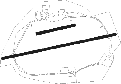
Runway info
Runway 08 / 26  | ||
| length | 1380m (4528ft) | |
| bearing | 86° / 266° | |
| width | 30m (98ft) | |
| surface | asphalt | |
| displ threshold | 244m (801ft) / 110m (361ft) | |
| blast zone | 18m (59ft) / 0m (0ft) | |
| Runway 08L / 26R | ||
| length | 450m (1476ft) | |
| bearing | 85° / 265° | |
| width | 35m (115ft) | |
| surface | grass | |
Nearby beacons
| code | identifier | dist | bearing | frequency |
|---|---|---|---|---|
| KHD | (HOLTENAU) DME-ILS | 0.2 | 250° | 109.50 |
| KIL | KIEL-HOLTENAU NDB | 1.1 | 264° | 353 |
| HN | HOHN NDB | 17.1 | 264° | 344 |
| HNT | HOHN TACAN | 21.8 | 263° | 115.30 |
| SWG | SCHLESWIG TACAN | 22.7 | 277° | 111.80 |
| ALS | ALSIE VOR | 31.9 | 343° | 114.70 |
| LYE | LUEBECK NDB | 39.7 | 137° | 394 |
| HAM | HAMBURG VORTAC | 41.8 | 176° | 113.10 |
| ALF | DME | 45.1 | 192° | 115.80 |
| VO | VOJENS/SKRYDSTRUP NDB | 59 | 314° | 321 |
| SKR | VOJENS/SKRYDSTRUP VORTAC | 60.3 | 312° | 110.40 |
Departure and arrival routes
| Transition altitude | 5000ft |
| SID end points | distance | outbound heading | |
|---|---|---|---|
| RW08 | |||
| LUGE1L | 32mi | 130° | |
| HAM1L, HAM1P | 42mi | 176° | |
| RENS1L | 15mi | 250° | |
| EKER1P, EKER6L | 13mi | 293° | |
| RW26 | |||
| LUGE1N | 32mi | 130° | |
| HAM9N, HAM1Q | 42mi | 176° | |
| RENS1N | 15mi | 250° | |
| EKER6N, EKER1Q | 13mi | 293° | |
Instrument approach procedures
| runway | airway (heading) | route (dist, bearing) |
|---|---|---|
| RW08 | KIL (84°) | KIL 2000ft HK081 (8mi, 274°) HK080 (2mi, 167°) 2000ft |
| RNAV | HK080 2000ft GETFO (3mi, 86°) 2000ft EDHK (6mi, 85°) 139ft HK089 (3mi, 86°) KIL (4mi, 266°) 2000ft | |
| RW26 | KIL (84°) | KIL 2000ft HK261 (10mi, 92°) HK260 (2mi, 347°) 2000ft |
| RNAV | HK260 2000ft BARQI (3mi, 266°) 2000ft EDHK (6mi, 266°) 139ft HK269 (3mi, 265°) KIL (2mi, 86°) 2000ft |
Disclaimer
The information on this website is not for real aviation. Use this data with the X-Plane flight simulator only! Data taken with kind consent from X-Plane 12 source code and data files. Content is subject to change without notice.