Dahlheim - Dahlemer Binz
Airport details
| Country | Germany |
| State | North Rhine-Westphalia |
| Region | ED |
| Airspace | Langen Ctr |
| Municipality | Dahlem |
| Elevation | 1895ft (578m) |
| Timezone | GMT +1 |
| Coordinates | 50.40567, 6.52900 |
| Magnetic var | |
| Type | land |
| Available since | X-Plane v10.40 |
| ICAO code | EDKV |
| IATA code | n/a |
| FAA code | n/a |
Communication
| Dahlemer Binz Dahlemer Binz Info | 130.085 |
Nearby Points of Interest:
Brigid of Kildare Chapel (Kronenburg)
-Barbarakapelle (Dahlem-Frauenkron)
-Kreuzkapelle Blankenheim (Ahr)
-Georgstor
-Kapelle St. Eligius
-Tempelheiligtum Zingsheim
-Schlosskirche Schleiden
-St. Martin (Freilingen)
-St. Leonhard
-Ehemalige Kapelle St. Antonius Eremita
-Alter Bahnhof Hillesheim
-Kirche St. Lambertus
-Kreuzweg
-St. Margareta
-Kapelle St. Kornelius
-Evangelisches Jugendheim Schleiden-Gemünd
-Chapel of St Rochus
-Trutzburg
-Bergstraße 15 und 17
-Kirche St. Anna
-Kreuz auf der Flins
-Burgmannenhaus (Aremberg)
-Jüdischer Friedhof
-Ordensburg Vogelsang
-Haus Rath
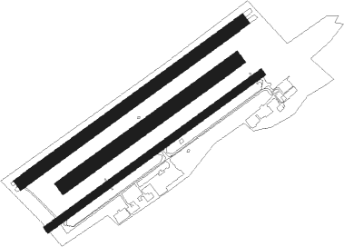
Runway info
Runway 06 / 24  | ||
| length | 1114m (3655ft) | |
| bearing | 69° / 249° | |
| width | 30m (98ft) | |
| surface | asphalt | |
| displ threshold | 318m (1043ft) / 37m (121ft) | |
| blast zone | 0m (0ft) / 154m (505ft) | |
| Runway 06L / 24R | ||
| length | 1155m (3789ft) | |
| bearing | 69° / 249° | |
| width | 50m (164ft) | |
| surface | grass | |
| Runway 06C / 24C | ||
| length | 901m (2956ft) | |
| bearing | 69° / 249° | |
| width | 60m (197ft) | |
| surface | grass | |
Nearby beacons
| code | identifier | dist | bearing | frequency |
|---|---|---|---|---|
| SLV | SPA NDB | 23.9 | 277° | 386 |
| BUE | BUECHEL TACAN | 24.8 | 113° | 117.10 |
| NVO | NOERVENICH VORTAC | 25.3 | 14° | 116.20 |
| WNN | DME | 26.3 | 18° | 109.85 |
| SPA | SPANGDAHLEM TACAN | 26.4 | 158° | 109.50 |
| LNO | OLNO VOR/DME | 33 | 282° | 112.80 |
| SPI | SPRIMONT VOR/DME | 35.2 | 277° | 113.10 |
| KBO | COLOGNE-BONN VOR/DME | 36 | 54° | 112.15 |
| DIK | DIEKIRCH NDB | 36.1 | 216° | 307 |
| LV | COLOGNE-BONN NDB | 36.1 | 61° | 327 |
| LJ | COLOGNE-BONN NDB | 37.3 | 46° | 365 |
| GIX | GEILENKIRCHEN TACAN | 38.2 | 319° | 108.10 |
| HAN | HAHN NDB | 39.2 | 120° | 376 |
| FHH | DME | 39.6 | 122° | 117.35 |
| MAS | MAASTRICHT VOR/DME | 40.3 | 315° | 108.60 |
| LW | COLOGNE-BONN NDB | 40.4 | 56° | 300 |
| ONL | LIEGE NDB | 41.3 | 287° | 290 |
| ELU | LUXEMBOURG NDB | 44.1 | 193° | 368 |
| NW | MAASTRICHT NDB | 44.3 | 313° | 373 |
| LE | LUXEMBOURG NDB | 47.2 | 200° | 318 |
| LUX | LUXEMBOURG VOR/DME | 47.2 | 200° | 112.25 |
| WYP | WIPPER VOR | 48 | 49° | 109.60 |
| LW | LUXEMBOURG NDB | 49.5 | 204° | 404 |
| MHD | DME | 49.8 | 357° | 112.50 |
| DY | DUESSELDORF NDB | 49.9 | 9° | 284 |
| MHV | MOENCHENGLADBACH VOR | 49.9 | 357° | 109.80 |
| DUS | DUESSELDORF VOR/DME | 53.3 | 14° | 115.15 |
| WLU | LUXEMBOURG NDB | 53.5 | 210° | 346 |
| LI | DUESSELDORF NDB | 58.1 | 21° | 417 |
| LMA | LIMA NDB | 58.1 | 352° | 311 |
| BAM | BARMEN VOR/DME | 60.5 | 35° | 114 |
Disclaimer
The information on this website is not for real aviation. Use this data with the X-Plane flight simulator only! Data taken with kind consent from X-Plane 12 source code and data files. Content is subject to change without notice.