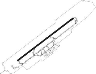
Paderborn - Paderborn Lippstadt
Airport details
| Country | Germany |
| State | North Rhine-Westphalia |
| Region | ED |
| Airspace | Langen Ctr |
| Municipality | Büren |
| Elevation | 699ft (213m) |
| Timezone | GMT +1 |
| Coordinates | 51.61409, 8.61632 |
| Magnetic var | |
| Type | land |
| Available since | X-Plane v10.40 |
| ICAO code | EDLP |
| IATA code | PAD |
| FAA code | n/a |
Communication
| Paderborn Lippstadt ATIS | 125.725 |
| Paderborn Lippstadt Ground Control | 121.925 |
| Paderborn Lippstadt Tower | 133.375 |
| Paderborn Lippstadt LANGEN RADAR | 125.225 |
Approach frequencies
| ILS-cat-I | RW06 | 111.15 | 18.00mi |
| ILS-cat-I | RW24 | 108.55 | 18.00mi |
| 3° GS | RW06 | 111.15 | 18.00mi |
| 3° GS | RW24 | 108.55 | 18.00mi |
Nearby beacons
| code | identifier | dist | bearing | frequency |
|---|---|---|---|---|
| PAD | DME-ILS | 0.2 | 149° | 108.50 |
| PAD | PADERBORN-LIPPSTADT NDB | 1 | 68° | 354 |
| WRB | WARBURG VOR/DME | 19.5 | 102° | 113.70 |
| DKS | DME-ILS | 31.6 | 104° | 111.50 |
| HMM | HAMM VOR/DME | 36.7 | 285° | 115.65 |
| DWI | DORTMUND-WICKEDE NDB | 37 | 265° | 357 |
| DOR | WICKEDE (DORTMUND) VOR/DME | 37.1 | 265° | 108.65 |
| OSB | OSNABRUCK TACAN | 37.2 | 331° | 108.35 |
| OSN | OSNABRUECK VOR | 37.2 | 331° | 114.30 |
| GMH | GERMINGHAUSEN VOR/DME | 38 | 239° | 115.40 |
| FTZ | FRITZLAR NDB | 43.7 | 124° | 468 |
| BYC | BUECKEBURG NDB | 44.2 | 35° | 368 |
| MYN | MUENSTER/OSNABRUECK NDB | 44.5 | 304° | 371 |
| MOD | DME | 46.6 | 299° | 114.05 |
| SLD | DME | 58.1 | 211° | 108.05 |
| WUN | WUNSTORF TACAN | 58.7 | 44° | 114.85 |
| SIL | SIEGERLAND NDB | 58.9 | 207° | 489 |
| DP | DIEPHOLZ NDB | 59 | 351° | 325 |
| HW | HANNOVER NDB | 61.7 | 47° | 358 |
Departure and arrival routes
| Transition altitude | 5000ft |
| SID end points | distance | outbound heading | |
|---|---|---|---|
| RW06 | |||
| WRB1X | 20mi | 102° | |
| GISD1X | 22mi | 150° | |
| TINS1X | 21mi | 260° | |
| DOME4X | 39mi | 275° | |
| RW24 | |||
| WRB1W | 20mi | 102° | |
| GISD1W | 22mi | 150° | |
| TINS1W | 21mi | 260° | |
| DOME5W | 39mi | 275° | |
| STAR starting points | distance | inbound heading | |
|---|---|---|---|
| ALL | |||
| PADB4H | 39.5 | 72° | |
| EXOB3H | 14.1 | 118° | |
| WRB6H | 19.5 | 282° | |
Instrument approach procedures
| runway | airway (heading) | route (dist, bearing) |
|---|---|---|
| RW06 | PAD (329°) | PAD LP025 (8mi, 212°) LP026 (5mi, 248°) LP027 (5mi, 313°) KOMIL (4mi, 68°) 3000ft |
| RNAV | KOMIL 3000ft EDLP (8mi, 68°) 749ft LP028 (4mi, 68°) LP040 (3mi, 176°) PAD (3mi, 276°) 3000ft | |
| RW24 | PAD (329°) | PAD LP020 (8mi, 91°) LP021 (5mi, 68°) LP022 (5mi, 314°) 3000ft IBEGO (4mi, 248°) 3000ft |
| RW24 | WRB (282°) | WRB LP021 (11mi, 312°) 5000ft LP022 (5mi, 314°) 3000ft IBEGO (4mi, 248°) 3000ft |
| RNAV | IBEGO 3000ft EDLP (8mi, 248°) 724ft LP023 (2mi, 248°) LP045 (3mi, 355°) PAD (3mi, 125°) 3000ft |
Holding patterns
| STAR name | hold at | type | turn | heading* | altitude | leg | speed limit |
|---|---|---|---|---|---|---|---|
| EXOB3H | PAD | FIX | right | 235 (55)° | > 3000ft | 1.0min timed | ICAO rules |
| PADB4H | PAD | FIX | right | 235 (55)° | > 3000ft | 1.0min timed | ICAO rules |
| PELU3H | PAD | FIX | right | 235 (55)° | > 3000ft | 1.0min timed | ICAO rules |
| WRB6H | PAD | FIX | right | 235 (55)° | > 3000ft | 1.0min timed | ICAO rules |
| WRB6H | WRB | NDB | right | 245 (65)° | > 5000ft | 1.0min timed | ICAO rules |
| *) magnetic outbound (inbound) holding course | |||||||
Disclaimer
The information on this website is not for real aviation. Use this data with the X-Plane flight simulator only! Data taken with kind consent from X-Plane 12 source code and data files. Content is subject to change without notice.
