Blaubeuren
Airport details
| Country | Germany |
| State | Baden-Württemberg |
| Region | ED |
| Airspace | Munich Ctr |
| Municipality | Blaubeuren |
| Elevation | 2216ft (675m) |
| Timezone | GMT +1 |
| Coordinates | 48.41972, 9.79889 |
| Magnetic var | |
| Type | land |
| Available since | X-Plane v10.40 |
| ICAO code | EDMC |
| IATA code | n/a |
| FAA code | n/a |
Communication
| Blaubeuren Blaubeuren Info | 130.500 |
Nearby Points of Interest:
Westernach’sches Kaplaneihaus
-Bemelberger Schlössle
-Gasthaus zum Rößle (Schelklingen)
-Burg Klingenstein
-Söflingen Abbey
-Namen-Jesu-Kirche
-Stadthaus Ulm
-Ulmer Münz
-Reichenauer Hof
-Ständehaus
-Rectory (Pfuhl)
-Altes Lager Münsingen
-Burgus Finningen
-Elchingen Abbey
-Alter Bau
-Pfarrhof (Unterelchingen)
-Siechenkapelle
-Unserer lieben Frau auf dem Kapf
-Postweg 1
-Feldkapelle Silheim
-Haus auf der Alb
-Stift Urach
-Rathaus
-Liebfrauenkapelle
-rectory
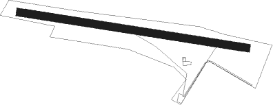
Runway info
| Runway 10 / 28 | ||
| length | 871m (2858ft) | |
| bearing | 279° / 99° | |
| width | 30m (98ft) | |
| surface | grass | |
Nearby beacons
| code | identifier | dist | bearing | frequency |
|---|---|---|---|---|
| LUP | LAUPHEIM NDB | 12.9 | 151° | 407 |
| TGO | TANGO TACAN | 24.5 | 290° | 112.50 |
| STG | STUTTGART VOR/DME | 27.2 | 297° | 116.85 |
| SGD | DME | 27.9 | 295° | 115.45 |
| ALD | (MEMMINGEN/ALLGAU) DME | 31.1 | 135° | 117.20 |
| ALG | ALLGAEU (MEMMINGEN) NDB | 31.4 | 132° | 341 |
| LBU | LUBURG VOR/DME | 34.7 | 317° | 109.20 |
| SHD | HALL DME | 41.8 | 358° | 108.05 |
| KPT | KEMPTEN VOR/DME | 46.1 | 141° | 108.40 |
| FHD | DME | 46.6 | 201° | 112.60 |
| DKB | DINKELSBUEHL VORTAC | 46.7 | 31° | 117.80 |
| NDD | DME-ILS | 58.8 | 9° | 108.70 |
| NSN | NIEDERSTETTEN NDB | 58.9 | 10° | 311 |
| ANS | ANSBACH NDB | 62.7 | 43° | 452 |
| ZUE | ZURICH EAST VOR/DME | 63.4 | 230° | 110.05 |
Disclaimer
The information on this website is not for real aviation. Use this data with the X-Plane flight simulator only! Data taken with kind consent from X-Plane 12 source code and data files. Content is subject to change without notice.