Giengen An Der Brenz - Gingen/brenz
Airport details
| Country | Germany |
| State | Baden-Württemberg |
| Region | ED |
| Airspace | Munich Ctr |
| Municipality | Giengen an der Brenz |
| Elevation | 1695ft (517m) |
| Timezone | GMT +1 |
| Coordinates | 48.63517, 10.21550 |
| Magnetic var | |
| Type | land |
| Available since | X-Plane v10.40 |
| ICAO code | EDNG |
| IATA code | n/a |
| FAA code | n/a |
Communication
| Gingen/Brenz Giengen Info | 122.350 |
Nearby Points of Interest:
Steiff-Fabrik
-Kloster Herbrechtingen
-Pfarrhaus (Bächingen an der Brenz)
-Dorfschmiede (Haunsheim)
-Hauptstraße 43
-Rathaus
-Rectory (Wittislingen)
-Marienplatz 5
-St. Vitus (Reistingen)
-Postamt Neresheim
-Cenotaph of Elisabeth von Pfalz-Neuburg
-Kaisheimer Kasten
-Herzog-Georg-Straße 4 (Lauingen)
-Rathaus in Lauingen (Donau)
-Synagogue in Lauingen
-Benefiziatenhaus
-Ehemaliges Gasthaus zum Adler
-Tränktor (Lauingen)
-Donaustraße 25
-Schloss Eglingen
-Bahnhof Neuoffingen
-Rectory (Hausen)
-rectory
-Institutstraße 14
-Rathaus (Günzburg)
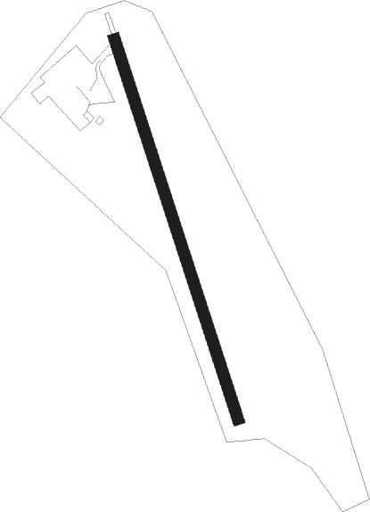
Runway info
| Runway 17 / 35 | ||
| length | 547m (1795ft) | |
| bearing | 160° / 340° | |
| width | 15m (49ft) | |
| surface | asphalt | |
| displ threshold | 0m (0ft) / 71m (233ft) | |
Nearby beacons
| code | identifier | dist | bearing | frequency |
|---|---|---|---|---|
| LUP | LAUPHEIM NDB | 27.8 | 216° | 407 |
| DKB | DINKELSBUEHL VORTAC | 30.4 | 3° | 117.80 |
| AGB | AUGSBURG NDB | 31.2 | 106° | 318 |
| AUG | DME | 31.3 | 106° | 115.90 |
| SHD | HALL DME | 33.6 | 318° | 108.05 |
| WLD | WALDA VOR/DME | 36.4 | 93° | 112.80 |
| LCH | LECHFELD TACAN | 37 | 125° | 108.80 |
| TGO | TANGO TACAN | 37.9 | 269° | 112.50 |
| STG | STUTTGART VOR/DME | 38.2 | 274° | 116.85 |
| ALG | ALLGAEU (MEMMINGEN) NDB | 38.3 | 176° | 341 |
| LBU | LUBURG VOR/DME | 38.4 | 288° | 109.20 |
| ALD | (MEMMINGEN/ALLGAU) DME | 38.8 | 179° | 117.20 |
| SGD | DME | 39.4 | 273° | 115.45 |
| NEU | NEUBURG TACAN | 39.7 | 86° | 108.90 |
| ANS | ANSBACH NDB | 43.6 | 32° | 452 |
| NDD | DME-ILS | 46.6 | 341° | 108.70 |
| NSN | NIEDERSTETTEN NDB | 46.6 | 342° | 311 |
| ILM | ILLESHEIM NDB | 50.7 | 12° | 488 |
| KPT | KEMPTEN VOR/DME | 53.6 | 171° | 108.40 |
| NUB | NUERNBERG VOR/DME | 61.2 | 43° | 115.75 |
| NGD | DME | 62.1 | 45° | 113.10 |
| FHD | DME | 64.7 | 216° | 112.60 |
Disclaimer
The information on this website is not for real aviation. Use this data with the X-Plane flight simulator only! Data taken with kind consent from X-Plane 12 source code and data files. Content is subject to change without notice.