Aalen - Aalen - Elchingen
Airport details
| Country | Germany |
| State | Baden-Württemberg |
| Region | ED |
| Airspace | Munich Ctr |
| Municipality | Neresheim |
| Elevation | 1916ft (584m) |
| Timezone | GMT +1 |
| Coordinates | 48.77783, 10.26467 |
| Magnetic var | |
| Type | land |
| Available since | X-Plane v10.30 |
| ICAO code | EDPA |
| IATA code | n/a |
| FAA code | n/a |
Communication
| Aalen - Elchingen Aalen Info | 121.405 |
| Aalen - Elchingen Aalen Segelflug | 123.155 |
Nearby Points of Interest:
Postamt Neresheim
-Jüdischer Friedhof Aufhausen
-Schloss Eglingen
-Christgarten Charterhouse
-Jupitergigantensäule von Walheim
-St. Michael
-St. Vitus (Reistingen)
-Steiff-Fabrik
-Bergerstraße 15
-Am Stänglesbrunnen 8
-Bergerstraße 8
-Eckhaus
-Bergerstraße 4
-Fachwerkhaus
-Lange Gasse 1
-Wohnhaus
-Bergerstraße 3
-Lange Gasse 19
-An der Baldinger Mauer 12
-Baldinger Straße 37
-Baldinger Straße 33 (Nördlingen)
-Baldinger Straße 35
-Baldinger Straße 44
-Baldinger Straße 25
-Baldinger Straße 27
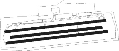
Runway info
Runway 09C / 27C  | ||
| length | 909m (2982ft) | |
| bearing | 89° / 269° | |
| width | 27m (89ft) | |
| surface | grass | |
| Runway 09R / 27L | ||
| length | 1012m (3320ft) | |
| bearing | 89° / 269° | |
| width | 26m (85ft) | |
| surface | grass | |
| Runway 09L / 27R | ||
| length | 1008m (3307ft) | |
| bearing | 89° / 269° | |
| width | 25m (82ft) | |
| surface | asphalt | |
| displ threshold | 55m (180ft) / 50m (164ft) | |
Nearby beacons
| code | identifier | dist | bearing | frequency |
|---|---|---|---|---|
| DKB | DINKELSBUEHL VORTAC | 21.9 | 356° | 117.80 |
| SHD | HALL DME | 27.9 | 305° | 108.05 |
| AGB | AUGSBURG NDB | 33.9 | 118° | 318 |
| AUG | DME | 34.1 | 118° | 115.90 |
| ANS | ANSBACH NDB | 35 | 35° | 452 |
| WLD | WALDA VOR/DME | 36.3 | 103° | 112.80 |
| LUP | LAUPHEIM NDB | 36.4 | 212° | 407 |
| LBU | LUBURG VOR/DME | 37.4 | 278° | 109.20 |
| NEU | NEUBURG TACAN | 37.6 | 94° | 108.90 |
| NDD | DME-ILS | 38.8 | 334° | 108.70 |
| NSN | NIEDERSTETTEN NDB | 38.8 | 334° | 311 |
| ILM | ILLESHEIM NDB | 41.9 | 10° | 488 |
| LCH | LECHFELD TACAN | 42.4 | 135° | 108.80 |
| ALG | ALLGAEU (MEMMINGEN) NDB | 46.8 | 180° | 341 |
| ALD | (MEMMINGEN/ALLGAU) DME | 47.4 | 182° | 117.20 |
| NUB | NUERNBERG VOR/DME | 53 | 47° | 115.75 |
| NGD | DME | 53.9 | 48° | 113.10 |
| RTB | ROETHENBACH NDB | 57.4 | 55° | 415 |
| ERL | ERLANGEN VOR/DME | 63.1 | 45° | 114.90 |
Disclaimer
The information on this website is not for real aviation. Use this data with the X-Plane flight simulator only! Data taken with kind consent from X-Plane 12 source code and data files. Content is subject to change without notice.