Airports for X-Plane offers a convenient way to explore airports and their related communication information for the X-Plane flight simulator. It only uses data from the X-Plane flight simulator itself, and is therefore more reliable than the data that comes from real aviation websites. You can search for airports by using the ICAO code, or browse for airports per country and state. The information displayed is categorized by airport details, runway information, airport communication, approach frequencies (ILS and Glidepath details), details of nearby beacons, SIDs, STARs and approach procedures.

airborne nearby air safety nation international airport arriving rail helicopters airspeed taxi airport check-in runway lighting airdock airstrip airfield downtown transit stol rail transport luggage

Speichersdorf - Rosenthal Field Ploessen

Airport details

CountryGermany
StateBavaria
RegionED
AirspaceMunich Ctr
MunicipalitySpeichersdorf
Elevation1496ft (456m)
TimezoneGMT +1
Coordinates49.86300, 11.78767
Magnetic var
Typeland
Available sinceX-Plane v10.40
ICAO codeEDQP
IATA coden/a
FAA coden/a

Communication

Rosenthal Field Ploessen Rosenthal Info127.450
Nearby Points of Interest:
Kleiner Kulm bei Neustadt am Kulm
-
St. Johannes Evangelist
-
Ehemaliges Kommunbrauhaus
-
Altes Rathaus
-
Stadtplatz 40
-
Alte Fronveste
-
Turmhügel Altencreußen
-
Burgruine Waldeck (Oberpfalz)
-
Rathaus
-
Burgruine Wurzstein
-
Giebelbau
-
Friedhofkirche Mater Dolorosa
-
Schloss Riglasreuth
-
Mariensäule
-
Schloss Nemmersdorf
-
Burgstall Lichteburg
-
Friedhof St. Georgen
-
Besucherbergwerke Goldkronach
-
Regierung von Oberfranken
-
Justizvollzugsanstalt St. Georgen-Bayreuth
-
Ellrodtscher Gartenportikus
-
Gericht
-
Justizpalast Bayreuth
-
Cultural heritage D-4-62-000-142 in Bayreuth
-
Baudenkmal

Runway info

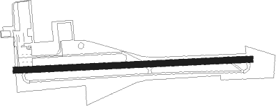
Runway 09 / 27
 length749m (2457ft)
 bearing91° / 271°
 width20m (66ft)
 surfaceasphalt
 displ threshold82m (269ft) / 50m (164ft)

Airport layout


Nearby beacons

codeidentifierdistbearingfrequency
BAYBAYREUTH VOR9.3309°110.60
GRWGRAFENWOHR NDB11.7138°405
GRFGRAFENWOHR TACAN11.8139°111.80
OKGCHEB VOR/DME26.772°115.70
ERLERLANGEN VOR/DME27.6252°114.90
RTBROETHENBACH NDB30.8235°415
NGDDME35243°113.10
NUBNUERNBERG VOR/DME36.3244°115.75
HFXHOHENFELS NDB38.8174°286
RDGRODING VOR/DME57.2138°114.70

Disclaimer

The information on this website is not for real aviation. Use this data with the X-Plane flight simulator only! Data taken with kind consent from X-Plane 12 source code and data files. Content is subject to change without notice.