Speyer
Airport details
| Country | Germany |
| State | Rhineland-Palatinate |
| Region | ED |
| Airspace | Langen Ctr |
| Municipality | Speyer |
| Elevation | 312ft (95m) |
| Timezone | GMT +1 |
| Coordinates | 49.30217, 8.45167 |
| Magnetic var | |
| Type | land |
| Available since | X-Plane v10.40 |
| ICAO code | EDRY |
| IATA code | ZQC |
| FAA code | n/a |
Communication
| Speyer Speyer INFO | 118.080 |
Nearby Points of Interest:
Jewish courtyard
-Stadthaus
-Johannesstraße 28
-St. Ludwig (Speyer)
-Ägidienkirche, Speyer
-Amtsgericht Speyer
-Villa Kirrmeier-Ecarius
-Castra of Wagbach
-Weingarten Town Hall
-Jüdischer Friedhof Walldorf
-Jüdischer Friedhof Schwetzingen
-Schlösschen im Park
-Bahnhof Lustadt
-Villa rustica bei Walldorf
-Wasserturm
-Jagdschloss Friedrichsbühl
-Wasserturm Duttweiler
-Rathaus Altdorf (Pfalz)
-Altes Rathaus Mutterstadt
-St. Peter
-Nachrichten Kaserne
-St. Nikolaus (Rettigheim)
-Stauwehr Wieblingen
-Synagogue (Rülzheim)
-Synagoge (Venningen)
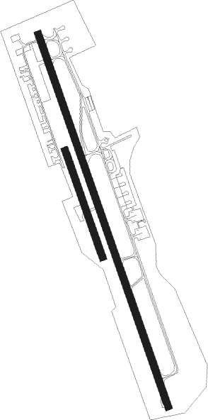
Runway info
Runway 16R / 34L  | ||
| length | 480m (1575ft) | |
| bearing | 158° / 338° | |
| width | 30m (98ft) | |
| surface | grass | |
| Runway 16 / 34 | ||
| length | 1679m (5509ft) | |
| bearing | 158° / 338° | |
| width | 30m (98ft) | |
| surface | asphalt | |
| displ threshold | 277m (909ft) / 277m (909ft) | |
Nearby beacons
| code | identifier | dist | bearing | frequency |
|---|---|---|---|---|
| MND | DME | 10.4 | 21° | 113.55 |
| NKR | NECKAR NDB | 11.2 | 83° | 292 |
| KRH | KARLSRUHE VOR/DME | 19.2 | 157° | 115.95 |
| RID | RIED VOR/DME | 29 | 11° | 112.20 |
| KBA | KARLSRUHE/BADEN-BADEN NDB | 33.3 | 215° | 431 |
| KBD | DME | 34.4 | 215° | 115.80 |
| RMS | RAMSTEIN TACAN | 34.7 | 279° | 113.40 |
| VFM | NAUHEIM VOR | 39.6 | 2° | 113.75 |
| LBU | LUBURG VOR/DME | 42 | 114° | 109.20 |
| FW | FRANKFURT NDB | 42.2 | 358° | 382 |
| CHA | CHARLIE VOR/DME | 43.6 | 44° | 115.35 |
| FRD | DME | 43.9 | 9° | 115.90 |
| WIB | WIESBADEN TACAN | 45 | 349° | 114.10 |
| FFM | FRANKFURT VORTAC | 45.7 | 14° | 114.20 |
| FR | FRANKFURT NDB | 46.7 | 17° | 297 |
| SGD | DME | 47.8 | 128° | 115.45 |
| STG | STUTTGART VOR/DME | 48.2 | 127° | 116.85 |
| SE | STRASBOURG NDB | 51.7 | 226° | 412 |
| TGO | TANGO TACAN | 51.9 | 130° | 112.50 |
| SUL | SULZ VOR | 55.8 | 168° | 116.10 |
| TAU | TAUNUS VOR/DME | 58 | 343° | 113.35 |
| STR | STRASBOURG ENTZHEIM VOR/DME | 59.1 | 228° | 115.60 |
| MTR | METRO VOR | 60.4 | 22° | 110 |
| LRD | DME | 61.5 | 214° | 108.05 |
| LHR | LAHR NDB | 62.6 | 214° | 337 |
Disclaimer
The information on this website is not for real aviation. Use this data with the X-Plane flight simulator only! Data taken with kind consent from X-Plane 12 source code and data files. Content is subject to change without notice.