Karlsruhe - Sinsheim
Airport details
| Country | Germany |
| State | Baden-Württemberg |
| Region | ED |
| Airspace | Langen Ctr |
| Municipality | Sinsheim |
| Elevation | 519ft (158m) |
| Timezone | GMT +1 |
| Coordinates | 49.24833, 8.89467 |
| Magnetic var | |
| Type | land |
| Available since | X-Plane v10.40 |
| ICAO code | EDTK |
| IATA code | n/a |
| FAA code | n/a |
Communication
| Sinsheim Sinsheim Info | 122.475 |
Nearby Points of Interest:
Jüdischer Friedhof Sinsheim
-Altes Pfarrhaus (Eschelbronn)
-Hintere Gasse 41 (Richen)
-Alte Kirche
-Gasthaus Löwen (Richen)
-Rentamt
-Untere Mühle (Eppingen)
-Timber framing in Eppingen
-Alte Post (Eppingen)
-Rathaus (Eppingen)
-Synagoge Metzgergasse (Eppingen)
-Diakonat
-Raußmühle
-Haus Mosbacher Straße 3
-St. Nikolaus (Rettigheim)
-Schloss Hochhausen
-Villa rustica bei Walldorf
-Rappengasse 6
-Synagoge (Gochsheim)
-Löwengasse 8 (Kürnbach)
-Gaisrain 58 (Kürnbach)
-Alte Synagoge
-Hartlesbrunnen
-Zehnthaus
-Jüdischer Friedhof Walldorf
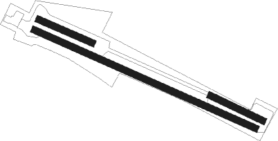
Runway info
Runway 12 / 30  | ||
| length | 1051m (3448ft) | |
| bearing | 109° / 289° | |
| width | 30m (98ft) | |
| surface | grass | |
| displ threshold | 260m (853ft) / 0m (0ft) | |
| Runway 11 / 29 | ||
| length | 250m (820ft) | |
| bearing | 109° / 289° | |
| width | 30m (98ft) | |
| surface | grass | |
| Runway 13 / 31 | ||
| length | 250m (820ft) | |
| bearing | 111° / 291° | |
| width | 30m (98ft) | |
| surface | grass | |
Nearby beacons
| code | identifier | dist | bearing | frequency |
|---|---|---|---|---|
| NKR | NECKAR NDB | 8.2 | 299° | 292 |
| KRH | KARLSRUHE VOR/DME | 19.5 | 231° | 115.95 |
| MND | DME | 19.9 | 300° | 113.55 |
| LBU | LUBURG VOR/DME | 26.6 | 127° | 109.20 |
| RID | RIED VOR/DME | 34.8 | 326° | 112.20 |
| SHD | HALL DME | 35.5 | 98° | 108.05 |
| SGD | DME | 36 | 150° | 115.45 |
| STG | STUTTGART VOR/DME | 36 | 147° | 116.85 |
| TGO | TANGO TACAN | 40.4 | 150° | 112.50 |
| CHA | CHARLIE VOR/DME | 40.7 | 12° | 115.35 |
| KBA | KARLSRUHE/BADEN-BADEN NDB | 41.4 | 241° | 431 |
| KBD | DME | 42.4 | 240° | 115.80 |
| VFM | NAUHEIM VOR | 45.9 | 329° | 113.75 |
| FRD | DME | 48.6 | 337° | 115.90 |
| FW | FRANKFURT NDB | 48.9 | 328° | 382 |
| FFM | FRANKFURT VORTAC | 49.3 | 342° | 114.20 |
| FR | FRANKFURT NDB | 49.7 | 346° | 297 |
| SUL | SULZ VOR | 52.9 | 196° | 116.10 |
| WIB | WIESBADEN TACAN | 53 | 324° | 114.10 |
Disclaimer
The information on this website is not for real aviation. Use this data with the X-Plane flight simulator only! Data taken with kind consent from X-Plane 12 source code and data files. Content is subject to change without notice.