Lahr
Airport details
| Country | Germany |
| State | Baden-Württemberg |
| Region | ED |
| Airspace | Langen Ctr |
| Municipality | Lahr/Schwarzwald |
| Elevation | 507ft (155m) |
| Timezone | GMT +1 |
| Coordinates | 48.36925, 7.82772 |
| Magnetic var | |
| Type | land |
| Available since | X-Plane v10.40 |
| ICAO code | EDTL |
| IATA code | LHA |
| FAA code | n/a |
Communication
| Lahr Lahr Info | 125.180 |
Approach frequencies
| ILS-cat-I | RW21 | 109.7 | 18.00mi |
| 3° GS | RW21 | 109.7 | 18.00mi |
Nearby Points of Interest:
Herberge zum Löwen
-église Saint-Martin d'Erstein
-Maison, 24 rue de Strasbourg (Erstein)
-Couvent Saint-Trophime d'Eschau
-Hôpital de Benfeld
-Centre de fermentation du tabac de Benfeld
-Maison au 46, route de Lyon à Fegersheim
-Maison au 23, rue de Lyon à Fegersheim
-Cité-jardin du Stockfeld
-Propriété Schranz
-Calvary (1770) of Geispolsheim
-Krimmeri signal box
-Ancienne usine Junkers (Strasbourg)
-Mairie de Krautergersheim
-maison Bowe
-chapelle du cimetière de Meistratzheim
-Ebersmunster Abbey
-enceinte de Strasbourg
-Citadelle de Strasbourg
-Hôpital civil, Strasbourg
-Hôpital militaire Gaujot
-Tour-porte de l'Hôpital civil de Strasbourg
-Maison au 2, rue de l'Abreuvoir à Strasbourg
-Ancien magasin Neunreiter
-Hôtel d'Ettenheimmunster
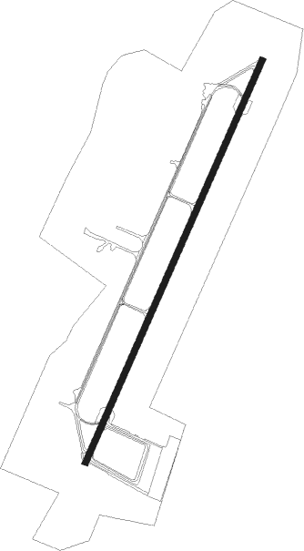
Runway info
| Runway 03 / 21 | ||
| length | 3004m (9856ft) | |
| bearing | 39° / 219° | |
| width | 45m (148ft) | |
| surface | asphalt | |
| blast zone | 255m (837ft) / 247m (810ft) | |
Nearby beacons
| code | identifier | dist | bearing | frequency |
|---|---|---|---|---|
| LRD | DME | 0.3 | 182° | 108.05 |
| LHR | LAHR NDB | 1.3 | 219° | 337 |
| STR | STRASBOURG ENTZHEIM VOR/DME | 13 | 298° | 115.60 |
| SE | STRASBOURG NDB | 13.9 | 333° | 412 |
| HO | COLMAR-HOUSSEN NDB | 23.2 | 243° | 380 |
| KBD | DME | 26.7 | 32° | 115.80 |
| KBA | KARLSRUHE/BADEN-BADEN NDB | 27.8 | 32° | 431 |
| SAV | SAVERNE VOR/DME | 29.7 | 318° | 110.45 |
| SUL | SULZ VOR | 32.6 | 89° | 116.10 |
| PHG | PHALSBOURG NDB | 34.5 | 302° | 424 |
| BN | BASLE-MULHOUSE NDB | 44.7 | 206° | 353 |
| BLM | BASLE-MULHOUSE VOR/DME | 46.1 | 204° | 117.45 |
| TRA | DME | 47.5 | 138° | 114.30 |
| KRH | KARLSRUHE VOR/DME | 47.9 | 50° | 115.95 |
| BS | BASLE-MULHOUSE NDB | 48.8 | 200° | 376 |
| ZWN | ZWEIBRUECKEN VOR/DME | 54.1 | 335° | 114.80 |
| HOC | DME | 54.6 | 190° | 113.20 |
| SR | ENSHEIM (SAARBRUECKEN) NDB | 56.3 | 324° | 360 |
| SAD | DME | 57.9 | 320° | 116.75 |
| ZUE | ZURICH EAST VOR/DME | 61.3 | 128° | 110.05 |
| KLO | KLOTEN (ZURICH) VOR/DME | 61.9 | 142° | 114.85 |
| MB | MONTBELIARD NDB | 63.4 | 226° | 330 |
| NKR | NECKAR NDB | 68.2 | 43° | 292 |
Departure and arrival routes
| Transition altitude | 5000ft |
| SID end points | distance | outbound heading | |
|---|---|---|---|
| RW03 | |||
| SUL6Q, SUL1W | 33mi | 89° | |
| NATO5Q, NATO1W | 23mi | 112° | |
| RW21 | |||
| SUL1X, SUL6R | 33mi | 89° | |
| NATO1X, NATO5R | 23mi | 112° | |
| STAR starting points | distance | inbound heading | |
|---|---|---|---|
| ALL | |||
| SUL1C, SUL4A | 32.6 | 269° | |
| RW21 | |||
| SUL1U, SUL6T | 32.6 | 269° | |
Instrument approach procedures
| runway | airway (heading) | route (dist, bearing) |
|---|---|---|
| RW03 | LHR (39°) | LHR 6000ft TL030 (6mi, 143°) 6000ft TL031 (11mi, 219°) 5000ft TL032 (5mi, 290°) 4000ft |
| RNAV | TL032 4000ft RIGNU (4mi, 39°) 4000ft EDTL (12mi, 39°) 561ft TL033 (12mi, 39°) LHR (13mi, 219°) 6000ft LHR (turn) 6000ft | |
| RW21 | KBA (212°) | KBA 6000ft TL210 (12mi, 202°) 4000ft |
| RW21 | LHR (39°) | LHR 6000ft TL212 (6mi, 84°) 6000ft TL211 (14mi, 39°) 5000ft TL210 (5mi, 290°) 4000ft |
| RW21 | SUL (269°) | SUL 6000ft TL213 (17mi, 281°) 6000ft TL211 (8mi, 313°) 6000ft TL210 (5mi, 290°) 4000ft |
| RNAV | TL210 4000ft APVER (4mi, 219°) 4000ft EDTL (12mi, 219°) 550ft TL214 (8mi, 219°) LHR (7mi, 39°) 6000ft LHR (turn) 6000ft |
Holding patterns
| STAR name | hold at | type | turn | heading* | altitude | leg | speed limit |
|---|---|---|---|---|---|---|---|
| KRH1C | KBA | FIX | right | 210 (30)° | > 6000ft | 1.0min timed | ICAO rules |
| KRH1C | LHR | FIX | right | 178 (358)° | > 6000ft | 1.0min timed | ICAO rules |
| KRH1U | KBA | FIX | right | 210 (30)° | > 6000ft | 1.0min timed | ICAO rules |
| KRH4T | KBA | FIX | right | 210 (30)° | > 6000ft | 1.0min timed | ICAO rules |
| KRH5A | KBA | FIX | right | 210 (30)° | > 6000ft | 1.0min timed | ICAO rules |
| KRH5A | LHR | FIX | right | 178 (358)° | > 6000ft | 1.0min timed | ICAO rules |
| SUL1C | LHR | FIX | right | 178 (358)° | > 6000ft | 1.0min timed | ICAO rules |
| SUL1U | KBA | FIX | right | 210 (30)° | > 6000ft | 1.0min timed | ICAO rules |
| SUL4A | LHR | FIX | right | 178 (358)° | > 6000ft | 1.0min timed | ICAO rules |
| SUL6T | KBA | FIX | right | 210 (30)° | > 6000ft | 1.0min timed | ICAO rules |
| *) magnetic outbound (inbound) holding course | |||||||
Disclaimer
The information on this website is not for real aviation. Use this data with the X-Plane flight simulator only! Data taken with kind consent from X-Plane 12 source code and data files. Content is subject to change without notice.