Airports for X-Plane offers a convenient way to explore airports and their related communication information for the X-Plane flight simulator. It only uses data from the X-Plane flight simulator itself, and is therefore more reliable than the data that comes from real aviation websites. You can search for airports by using the ICAO code, or browse for airports per country and state. The information displayed is categorized by airport details, runway information, airport communication, approach frequencies (ILS and Glidepath details), details of nearby beacons, SIDs, STARs and approach procedures.

city hospital immigration train helicopters taxi airfield landing area seaplanes government southwest jet flight attendant port runway lighting airliner buildings runway kennedy tarmac

Gransee

Airport details

CountryGermany
StateBrandenburg
Region
AirspaceBremen Ctr
MunicipalityGransee
Elevation164ft (50m)
TimezoneGMT +1
Coordinates53.00795, 13.19556
Magnetic var
Typeland
Available sinceX-Plane v10.40
ICAO codeEDUG
IATA coden/a
FAA coden/a

Communication

Gransee Gransee Fallschirm126.725
Nearby Points of Interest:
Village church Altlüdersdorf
-
Dorfkirche Zabelsdorf
-
Village church Gutengermendorf
-
Village church Schulzendorf (Sonnenberg)
-
Village church Rönnebeck
-
Village church Blumenow
-
Village church Keller
-
Burgwall Liebenberg
-
Village church Barsdorf
-
Gutsanlage Liebenberg
-
Village church Falkenthal
-
Parish church Lindow in der Mark
-
Village church Bredereiche
-
Village church Hammelspring
-
Herzberg church
-
Stadtkirche Liebenwalde
-
Church in Fürstenberg/Havel
-
Ravensbrück Memorial
-
Finow Canal
-
Kulturzentrum Bürgergarten Templin
-
Village church Kreuzbruch
-
Hellmuth Ulrici Clinic
-
Burgwall Lychen
-
Pfarrkirche St. Nikolai
-
Ruppin Castle

Runway info

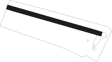
Runway 11 / 29
 length851m (2792ft)
 bearing103° / 283°
 width40m (131ft)
 surfacegrass
 displ threshold100m (328ft) / 100m (328ft)

Airport layout


Nearby beacons

codeidentifierdistbearingfrequency
LWBLOEWENBERG VOR/DME6.2212°114.55
SDDDME39.6154°114.40
BBIBERLIN BRANDENBURG VOR/DME41159°114.10
FLDFRIEDLAND VOR/DME47.226°117.15
FWEFUERSTENWALDE VOR/DME49.4123°113.30
KLFKLASDORF VOR/DME60.8160°115.15
HCHERINGSDORF NDB62.849°330
LAGLAAGE TACAN63.6315°108.25

Disclaimer

The information on this website is not for real aviation. Use this data with the X-Plane flight simulator only! Data taken with kind consent from X-Plane 12 source code and data files. Content is subject to change without notice.