Airports for X-Plane offers a convenient way to explore airports and their related communication information for the X-Plane flight simulator. It only uses data from the X-Plane flight simulator itself, and is therefore more reliable than the data that comes from real aviation websites. You can search for airports by using the ICAO code, or browse for airports per country and state. The information displayed is categorized by airport details, runway information, airport communication, approach frequencies (ILS and Glidepath details), details of nearby beacons, SIDs, STARs and approach procedures.

road luggage warfare passenger non-towered airport airspeed station drome landing embassy seaplane airbus international air traffic control airport check-in plane heliport local government rail transport near

Zerbst/anhalt - Zerbst

Airport details

CountryGermany
StateSaxony-Anhalt
RegionED
AirspaceBremen Ctr
MunicipalityZerbst/Anhalt
Elevation266ft (81m)
TimezoneGMT +1
Coordinates51.99855, 12.14869
Magnetic var
Typeland
Available sinceX-Plane v10.40
ICAO codeEDUZ
IATA coden/a
FAA coden/a

Communication

Zerbst Zerbst Info123.050
Nearby Points of Interest:
Lindau (Anhalt) railway station
-
Schloss Bärenthoren
-
Dorfkirche Rodleben
-
Dorfkirche Göbel (Möckern)
-
St. Johannis (Gehrden)
-
Dolmen Gehrden
-
Kriegerdenkmal Loburg
-
St. Nicolai (Steckby)
-
Bootshaus im Leopoldshafen
-
Dessau-Wörlitz Garden Realm
-
Schloss Wendgräben
-
Aken railway station
-
Dessau Aerodrome
-
Schwabehaus
-
Palais Branconi (Dessau)
-
Palais Waldersee
-
Villa Kämmerer
-
Dessau
-
Village church Klein Lübars
-
Reetz church
-
Altes Pfarrhaus
-
Windmühle Wallwitz
-
Hofmeisterhaus
-
Gebberskreuz
-
Pretziener Wehr

Runway info

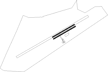
Runway 07R / 25L  
 length751m (2464ft)
 bearing74° / 254°
 width30m (98ft)
 surfacegrass
Runway 07L / 25R  
 length751m (2464ft)
 bearing74° / 254°
 width30m (98ft)
 surfaceconcrete

Airport layout


Nearby beacons

codeidentifierdistbearingfrequency
MAGMAGDEBURG VOR/DME13.1269°110.45
CBCOCHSTEDT NDB27.1259°344
LNDNORTH(LEIPZIG- DME34172°113.50
ZIGLEIPZIG NDB34.2167°340
LLDSOUTH(LEIPZIG- DME35.1172°112.15
SKZSCHKEUDITZ (LEIPZIG-HALLE) NDB35.3168°357
LEGLEIPZIG VOR/DME35.8150°115.85
HOZHOLZDORF NDB37.7104°406
GOTGOTEM VOR/DME44.3220°115.25
LWBLOEWENBERG VOR/DME65.547°114.55

Disclaimer

The information on this website is not for real aviation. Use this data with the X-Plane flight simulator only! Data taken with kind consent from X-Plane 12 source code and data files. Content is subject to change without notice.