Bad Gandersheim
Airport details
| Country | Germany |
| State | Lower Saxony |
| Region | ED |
| Airspace | Bremen Ctr |
| Municipality | Bad Gandersheim |
| Elevation | 779ft (237m) |
| Timezone | GMT +1 |
| Coordinates | 51.85283, 10.02650 |
| Magnetic var | |
| Type | land |
| Available since | X-Plane v10.30 |
| ICAO code | EDVA |
| IATA code | n/a |
| FAA code | n/a |
Communication
| Bad Gandersheim Gandersheim Info | 128.800 |
Nearby Points of Interest:
Gandersheim Abbey
-St. Martinskirche (Greene, Lower Saxony)
-Burg Hausfreden
-Burg Westerhof
-Saint Martin Church
-Einbeck Municipal Museum
-St. Laurentius
-Tiedexer Straße
-Alte Synagoge
-Clarissenkloster (Einbeck)
-Kornhaus
-St. Georg
-Kirche Mariä Geburt
-St. Johannes
-St. Mauritius (Almstedt)
-Burg Moringen
-St. Nicolaikapelle
-Upper Harz Water Regale
-Alte Burg
-Eulenburg
-St. Georgskirche
-Antoniuskirche
-St. Laurentiuskirche
-Jewish cemetery, Dassel
-St. Georgskapelle
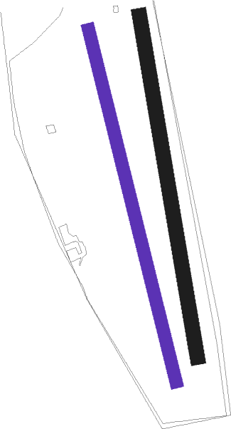
Runway info
| Runway 17R / 35L | ||
| length | 865m (2838ft) | |
| bearing | 165° / 345° | |
| width | 30m (98ft) | |
| surface | grass | |
Runway 17 / 35  | ||
| length | 826m (2710ft) | |
| bearing | 172° / 352° | |
| width | 35m (115ft) | |
| surface | grass | |
Nearby beacons
| code | identifier | dist | bearing | frequency |
|---|---|---|---|---|
| DLE | LEINE VOR/DME | 24.4 | 340° | 115.20 |
| SAS | SARSTEDT VOR/DME | 24.4 | 340° | 114.45 |
| DKS | DME-ILS | 34.7 | 235° | 111.50 |
| BRU | BRAUNSCHWEIG-WOLFSBURG NDB | 35.3 | 51° | 427 |
| HA | HANNOVER NDB | 37.6 | 340° | 320 |
| HBD | DME | 38.6 | 329° | 116.90 |
| HAD | DME | 38.9 | 332° | 113.95 |
| WRB | WARBURG VOR/DME | 39.9 | 249° | 113.70 |
| HW | HANNOVER NDB | 40.9 | 322° | 358 |
| HLZ | HEHLINGEN VOR/DME | 41.7 | 56° | 117.30 |
| WUN | WUNSTORF TACAN | 42.3 | 315° | 114.85 |
| BYC | BUECKEBURG NDB | 43.4 | 295° | 368 |
| CEL | CELLE NDB | 44.2 | 0° | 311 |
| FTZ | FRITZLAR NDB | 51.5 | 218° | 468 |
| NIE | NIENBURG VOR | 52.2 | 320° | 116.50 |
| EFD | DME | 62.8 | 133° | 112.05 |
Disclaimer
The information on this website is not for real aviation. Use this data with the X-Plane flight simulator only! Data taken with kind consent from X-Plane 12 source code and data files. Content is subject to change without notice.