Höxter - Hoexter-holzminden
Airport details
| Country | Germany |
| State | North Rhine-Westphalia |
| Region | ED |
| Airspace | Bremen Ctr |
| Municipality | Höxter |
| Elevation | 935ft (285m) |
| Timezone | GMT +1 |
| Coordinates | 51.80639, 9.37833 |
| Magnetic var | |
| Type | land |
| Available since | X-Plane v10.40 |
| ICAO code | EDVI |
| IATA code | n/a |
| FAA code | n/a |
Communication
| Hoexter-Holzminden Hoexter Info | 123.625 |
Nearby Points of Interest:
Obermühle
-Amtsgericht Höxter
-Adelshof Heisterman von Ziehlberg
-Rathaus Höxter
-Dreizehnlindenhaus
-Dreizehnlinden-Kreuz
-Felsenkeller (Höxter)
-Jewish cemetery, Vörden, Marienmünster
-Schloss Amelunxen
-St. Jakobus d. Ä. und Christophorus
-St. Mariä Himmelfahrt (Bruchhausen)
-Gut Grevenburg
-Rathaus Nieheim
-Jewish Cemetery, Sievershausen
-Haus Suchier
-Rathaus Bad Karlshafen
-Invalidenhaus
-St. Trinitatiskirche
-Jewish cemetery, Dassel
-Hünenburg
-Mariä Himmelfahrt
-Hajener Hungerstein
-Mariä Verkündigung
-Rommenhöller-Denkmal
-Bauernburg Ottenhausen
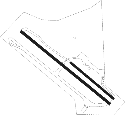
Runway info
Runway 13 / 31  | ||
| length | 394m (1293ft) | |
| bearing | 121° / 301° | |
| width | 15m (49ft) | |
| surface | grass | |
| Runway 14 / 32 | ||
| length | 813m (2667ft) | |
| bearing | 120° / 300° | |
| width | 20m (66ft) | |
| surface | asphalt | |
Nearby beacons
| code | identifier | dist | bearing | frequency |
|---|---|---|---|---|
| WRB | WARBURG VOR/DME | 20.6 | 222° | 113.70 |
| DKS | DME-ILS | 23.1 | 176° | 111.50 |
| PAD | PADERBORN-LIPPSTADT NDB | 29.6 | 256° | 354 |
| PAD | DME-ILS | 30.6 | 256° | 108.50 |
| BYC | BUECKEBURG NDB | 30.9 | 329° | 368 |
| DLE | LEINE VOR/DME | 32.5 | 49° | 115.20 |
| SAS | SARSTEDT VOR/DME | 32.5 | 49° | 114.45 |
| WUN | WUNSTORF TACAN | 38.9 | 5° | 114.85 |
| HW | HANNOVER NDB | 40.2 | 14° | 358 |
| HBD | DME | 40.3 | 23° | 116.90 |
| HAD | DME | 41.4 | 26° | 113.95 |
| HA | HANNOVER NDB | 42.5 | 33° | 320 |
| FTZ | FRITZLAR NDB | 43.3 | 177° | 468 |
| NIE | NIENBURG VOR | 49.2 | 360° | 116.50 |
| CEL | CELLE NDB | 52.7 | 40° | 311 |
| DP | DIEPHOLZ NDB | 58.1 | 310° | 325 |
Disclaimer
The information on this website is not for real aviation. Use this data with the X-Plane flight simulator only! Data taken with kind consent from X-Plane 12 source code and data files. Content is subject to change without notice.