Juist
Airport details
| Country | Germany |
| State | Lower Saxony |
| Region | ED |
| Airspace | Bremen Ctr |
| Municipality | Juist |
| Elevation | 4ft (1m) |
| Timezone | GMT +1 |
| Coordinates | 53.68067, 7.05783 |
| Magnetic var | |
| Type | land |
| Available since | X-Plane v10.40 |
| ICAO code | EDWJ |
| IATA code | JUI |
| FAA code | n/a |
Communication
| Juist Juist INFO | 120.500 |
Nearby Points of Interest:
Schöningh House
-St.-Ludgerus-Kirche
-Dree Süsters
-Christuskirche (Norden)
-Conerusspeicher
-Appingen Abbey
-Tjücher Mühle
-Beningaburg (Grimersum)
-Wirdum Church
-Petrikirche
-Rentmeisterhaus (Uttum)
-The Evangelical Reformed St. Peter Church in Groothusen
-Pewsum Church
-Haus Teerling
-Marienkirche (Woquard)
-Canhuser Kirche
-Westerbur Church (Dornum)
-Wasserschöpfmühle Agnes
-Loppersumer Kirche
-Burg Westerhusen
-Old-Reformed Church (Campen)
-Mühle Hinte
-Reformierte Kirche
-Bedekaspel Church (Südbrookmerland)
-St. Martin
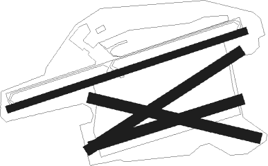
Runway info
Runway 08 / 26  | ||
| length | 699m (2293ft) | |
| bearing | 82° / 262° | |
| width | 20m (66ft) | |
| surface | concrete | |
| Runway 12 / 30 | ||
| length | 475m (1558ft) | |
| bearing | 101° / 281° | |
| width | 30m (98ft) | |
| surface | grass | |
| Runway 06 / 24 | ||
| length | 500m (1640ft) | |
| bearing | 72° / 252° | |
| width | 30m (98ft) | |
| surface | grass | |
| Runway 08R / 26L | ||
| length | 428m (1404ft) | |
| bearing | 82° / 262° | |
| width | 30m (98ft) | |
| surface | grass | |
Nearby beacons
| code | identifier | dist | bearing | frequency |
|---|---|---|---|---|
| WTM | WITTMUNDHAFEN TACAN | 24.9 | 101° | 113.50 |
| EEL | EELDE (GRONINGEN) VOR/DME | 34 | 217° | 112.40 |
| DHE | HELGOLAND VOR/DME | 42.7 | 59° | 116.30 |
Disclaimer
The information on this website is not for real aviation. Use this data with the X-Plane flight simulator only! Data taken with kind consent from X-Plane 12 source code and data files. Content is subject to change without notice.