Borkum
Airport details
| Country | Germany |
| State | Lower Saxony |
| Region | ED |
| Airspace | Bremen Ctr |
| Municipality | Borkum |
| Elevation | 2ft (1m) |
| Timezone | GMT +1 |
| Coordinates | 53.59550, 6.70917 |
| Magnetic var | |
| Type | land |
| Available since | X-Plane v10.30 |
| ICAO code | EDWR |
| IATA code | BMK |
| FAA code | n/a |
Communication
| Borkum BREMEN INFORMATION | 121.210 |
Nearby Points of Interest:
Haus Teerling
-Mennonietenkerkstraat 13, Uithuizen
-Rouwkapel, Uithuizen
-Nicolaaskerk, Oosternieland
-Maarlandhoeve
-Hervormde Kerk Usquert
-Doopsgezinde Vermaning (Zijldijk)
-Fivelweg 31, Zijldijk
-Langenhuis
-Kerk van Zandeweer
-Atelierwoning
-Oosterstraat 67
-Vrouw Fransensgasthuis
-Hoofdstraat 19, Warffum
-De Schakel
-Hervormde pastorie, Warffum
-Voormalige Hervormde Kerk
-Omtadaburgh
-Villaboerderij in Amsterdamse Schoolstijl
-Nederlands Hervormde Kerk, Losdorp
-Burgemeesterswoning met achterhuis en koetshuis
-Mariakerk, 't Zandt
-Nederlands Hervormde Kerk, Kantens
-Alberdaheerd
-Nederlands Hervormde Kerk
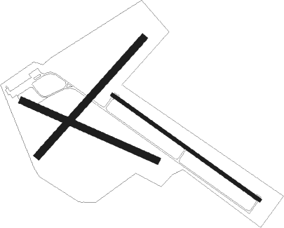
Runway info
Runway 13 / 31  | ||
| length | 1001m (3284ft) | |
| bearing | 116° / 296° | |
| width | 20m (66ft) | |
| surface | asphalt | |
| Runway 12 / 30 | ||
| length | 811m (2661ft) | |
| bearing | 108° / 288° | |
| width | 40m (131ft) | |
| surface | grass | |
| displ threshold | 91m (299ft) / 0m (0ft) | |
| Runway 05 / 23 | ||
| length | 871m (2858ft) | |
| bearing | 60° / 240° | |
| width | 40m (131ft) | |
| surface | grass | |
Nearby beacons
| code | identifier | dist | bearing | frequency |
|---|---|---|---|---|
| EEL | EELDE (GRONINGEN) VOR/DME | 25.9 | 186° | 112.40 |
| LWD | LEEUWARDEN TACAN | 40.9 | 249° | 114.70 |
Disclaimer
The information on this website is not for real aviation. Use this data with the X-Plane flight simulator only! Data taken with kind consent from X-Plane 12 source code and data files. Content is subject to change without notice.