Helgoland - Helgoland-dune
Airport details
| Country | Germany |
| State | Schleswig-Holstein |
| Region | ED |
| Airspace | Bremen Ctr |
| Municipality | Helgoland - deät Lun |
| Elevation | 7ft (2m) |
| Timezone | GMT +1 |
| Coordinates | 54.18533, 7.91583 |
| Magnetic var | |
| Type | land |
| Available since | X-Plane v10.40 |
| ICAO code | EDXH |
| IATA code | HGL |
| FAA code | n/a |
Communication
| Helgoland-Dune Helgoland Info | 122.455 |
Nearby Points of Interest:
Hummerbuden
-Bürgermeister O´Swald II
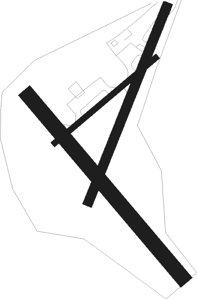
Runway info
Runway 06 / 24  | ||
| length | 265m (869ft) | |
| bearing | 67° / 247° | |
| width | 12m (39ft) | |
| surface | concrete | |
| Runway 15 / 33 | ||
| length | 476m (1562ft) | |
| bearing | 129° / 309° | |
| width | 30m (98ft) | |
| surface | concrete | |
| Runway 03 / 21 | ||
| length | 420m (1378ft) | |
| bearing | 40° / 220° | |
| width | 20m (66ft) | |
| surface | concrete | |
Nearby beacons
| code | identifier | dist | bearing | frequency |
|---|---|---|---|---|
| DHE | HELGOLAND VOR/DME | 0.1 | 274° | 116.30 |
| NDO | NORDHOLZ TACAN | 36.1 | 119° | 117.10 |
| WTM | WITTMUNDHAFEN TACAN | 38.4 | 197° | 113.50 |
| NDO | NORDHOLZ NDB | 39.5 | 114° | 372 |
| SLT | WESTERLAND/SYLT NDB | 43.8 | 36° | 387 |
| WES | DME-ILS | 45.9 | 30° | 111.50 |
| WSN | WESER NDB | 60.7 | 131° | 378 |
Disclaimer
The information on this website is not for real aviation. Use this data with the X-Plane flight simulator only! Data taken with kind consent from X-Plane 12 source code and data files. Content is subject to change without notice.