Harlesiel - Harle
Airport details
| Country | Germany |
| State | Lower Saxony |
| Region | ED |
| Airspace | Bremen Ctr |
| Municipality | Wangerland |
| Elevation | 4ft (1m) |
| Timezone | GMT +1 |
| Coordinates | 53.70700, 7.82133 |
| Magnetic var | |
| Type | land |
| Available since | X-Plane v10.40 |
| ICAO code | EDXP |
| IATA code | n/a |
| FAA code | n/a |
Communication
| Harle Harle Info | 122.400 |
Nearby Points of Interest:
Carolinensiel church
-Altfunnixsieler Mühle
-St. Marienkirche
-St. Florian
-Jüdischer Friedhof Esens
-St. Stephanuskirche
-Westerbur Church (Dornum)
-Petrikirche
-Lutherische Kirche
-Holy Cross Church
-Andreaskirche
-Bavariahaus
-Strandhalle Wilhelmshaven
-Woltzetener Kirche
-Wasserwerk Aurich
-Friedhofswärterhaus
-Staatshochbauamt
-Evertssches Haus
-St.-Ludgerus-Kirche
-Pingelhus
-Aurich railway station
-Landschaftshaus
-Denkmal für die Gefallenen des Deutsch-Französischen Krieges 1870/71 (Aurich)
-Ostgroßefehner Kirche
-Holtrop Church
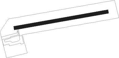
Runway info
| Runway 08 / 26 | ||
| length | 533m (1749ft) | |
| bearing | 87° / 267° | |
| width | 20m (66ft) | |
| surface | asphalt | |
| displ threshold | 18m (59ft) / 0m (0ft) | |
Nearby beacons
| code | identifier | dist | bearing | frequency |
|---|---|---|---|---|
| WTM | WITTMUNDHAFEN TACAN | 9.7 | 212° | 113.50 |
| DHE | HELGOLAND VOR/DME | 28.9 | 11° | 116.30 |
| NDO | NORDHOLZ TACAN | 29.7 | 86° | 117.10 |
| NDO | NORDHOLZ NDB | 35.2 | 85° | 372 |
| BMN | BREMEN VOR/DME | 52 | 125° | 117.45 |
| BND | DME | 52.6 | 125° | 113.65 |
Disclaimer
The information on this website is not for real aviation. Use this data with the X-Plane flight simulator only! Data taken with kind consent from X-Plane 12 source code and data files. Content is subject to change without notice.