Rotenburg (wümme) - Rotenburg Wuemme
Airport details
| Country | Germany |
| State | Lower Saxony |
| Region | ED |
| Airspace | Bremen Ctr |
| Municipality | Rotenburg |
| Elevation | 97ft (30m) |
| Timezone | GMT +1 |
| Coordinates | 53.13038, 9.35701 |
| Magnetic var | |
| Type | land |
| Available since | X-Plane v10.40 |
| ICAO code | EDXQ |
| IATA code | n/a |
| FAA code | n/a |
Communication
| Rotenburg Wuemme Wuemme Info | 122.050 |
Nearby Points of Interest:
Burg Clüversborstel
-St. Margarethen (Gyhum)
-Christophorus-Kirche
-Alte Posthalterei
-Wassermühle Bademühlen
-Sankt Antonius
-St. Petrikirche
-Egestorff Foundation
-Gaststätte Meyer am Boom
-Brinksitzerhaus
-Haus Hoogenkamp
-Landhaus Waldthausen
-Landhaus Böving
-Landsitz Caesar-Ichon
-Amtsgericht Tostedt
-Wohnhaus Lindenweg 12
-Klinikum Bremen-Ost
-Haus Schumacher
-Landsitz Hasse
-Johanneskirche
-Wohnhaus Oberneulander Landstraße 141A
-Wikingborg
-Bauernhaus Osterholzer Dorfstrasse 29
-Landgut Arndt-Soltmann
-Haus Weltmann
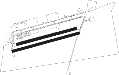
Runway info
Runway 08 / 26  | ||
| length | 798m (2618ft) | |
| bearing | 83° / 263° | |
| width | 30m (98ft) | |
| surface | asphalt | |
| Runway 07 / 25 | ||
| length | 707m (2320ft) | |
| bearing | 84° / 264° | |
| width | 30m (98ft) | |
| surface | grass | |
Nearby beacons
| code | identifier | dist | bearing | frequency |
|---|---|---|---|---|
| HIG | BREMEN NDB | 16.8 | 260° | 318 |
| BND | DME | 21.3 | 261° | 113.65 |
| WSN | WESER NDB | 21.6 | 294° | 378 |
| BMN | BREMEN VOR/DME | 22.1 | 262° | 117.45 |
| NIE | NIENBURG VOR | 30.3 | 178° | 116.50 |
| FSB | FASSBERG NDB | 32.6 | 104° | 284 |
| ALF | DME | 37.9 | 52° | 115.80 |
| HW | HANNOVER NDB | 40.3 | 164° | 358 |
| CEL | CELLE NDB | 40.6 | 129° | 311 |
| WUN | WUNSTORF TACAN | 40.6 | 174° | 114.85 |
| HAD | DME | 41.5 | 153° | 113.95 |
| HBD | DME | 42 | 156° | 116.90 |
| HA | HANNOVER NDB | 43.1 | 146° | 320 |
| NDO | NORDHOLZ NDB | 43.9 | 320° | 372 |
| HAM | HAMBURG VORTAC | 45 | 57° | 113.10 |
| NDO | NORDHOLZ TACAN | 45.8 | 312° | 117.10 |
| DP | DIEPHOLZ NDB | 46 | 239° | 325 |
| BYC | BUECKEBURG NDB | 51.3 | 198° | 368 |
| DLE | LEINE VOR/DME | 56.2 | 149° | 115.20 |
| SAS | SARSTEDT VOR/DME | 56.2 | 149° | 114.45 |
Disclaimer
The information on this website is not for real aviation. Use this data with the X-Plane flight simulator only! Data taken with kind consent from X-Plane 12 source code and data files. Content is subject to change without notice.