Kuressaare
Airport details
| Country | Estonia |
| State | Saare County |
| Region | EE |
| Airspace | Tallinn Ctr |
| Municipality | Kuressaare |
| Elevation | 15ft (5m) |
| Timezone | GMT +2 |
| Coordinates | 58.23458, 22.50507 |
| Magnetic var | |
| Type | land |
| Available since | X-Plane v10.40 |
| ICAO code | EEKE |
| IATA code | URE |
| FAA code | n/a |
Communication
| Kuressaare Kuressaare Information | 118.050 |
Approach frequencies
| ILS-cat-I | RW17 | 109.9 | 18.00mi |
| 3° GS | RW17 | 109.9 | 18.00mi |
Nearby Points of Interest:
Põlluvahi maja
-Kuressaare tuuleveski
-Saaremaa rüütelkonna hoone
-Kuressaare vaekoda
-Sadamaait
-Kuressaare suursild
-Loode wooded meadow
-Pähkla allikas
-Abruka Nature Reserve
-Järve Dunes' Nature Park
-Tehumardi memorial
-Liiva-Putla Nature Reserve
-Viidumäe Nature Reserve
-Küdema kurisud
-Võhma maalinn
-Mõntu park
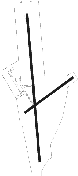
Runway info
Runway 17 / 35  | ||
| length | 1997m (6552ft) | |
| bearing | 179° / 359° | |
| width | 30m (98ft) | |
| surface | asphalt | |
| blast zone | 30m (98ft) / 0m (0ft) | |
| Runway 05 / 23 | ||
| length | 797m (2615ft) | |
| bearing | 72° / 252° | |
| width | 30m (98ft) | |
| surface | asphalt | |
| blast zone | 95m (312ft) / 0m (0ft) | |
Nearby beacons
| code | identifier | dist | bearing | frequency |
|---|---|---|---|---|
| KRS | KURESSAARE VOR/DME | 0.4 | 121° | 112.40 |
| OZ | KARDLA NDB | 44.8 | 27° | 317 |
| O | KARDLA NDB | 46 | 24° | 386 |
| KRD | DME | 46.6 | 23° | 117.60 |
| VEN | VENTSPILS VOR/DME | 61.9 | 228° | 117.85 |
Instrument approach procedures
| runway | airway (heading) | route (dist, bearing) |
|---|---|---|
| RW17 | ABRAD (220°) | ABRAD 3000ft UDVAS (5mi, 270°) 2000ft |
| RW17 | INROK (141°) | INROK 3000ft UDVAS (5mi, 90°) 2000ft |
| RNAV | UDVAS 2000ft DEVEK (5mi, 179°) 2000ft EEKE (7mi, 182°) 64ft KE550 (4mi, 175°) UMVOX (10mi, 227°) 2000ft UMVOX (turn) 2000ft | |
| RW35 | ADVES (321°) | ADVES 3000ft OSMIP (5mi, 270°) 2000ft |
| RW35 | UMVOX (36°) | UMVOX 3000ft OSMIP (5mi, 90°) 2000ft |
| RNAV | OSMIP 2000ft BEBVI (5mi, 359°) 2000ft EEKE (7mi, 357°) 58ft KE850 (3mi, 4°) ABRAD (10mi, 49°) 2000ft ABRAD (turn) 2000ft |
Disclaimer
The information on this website is not for real aviation. Use this data with the X-Plane flight simulator only! Data taken with kind consent from X-Plane 12 source code and data files. Content is subject to change without notice.