Eura
Airport details
| Country | Finland |
| State | Western Finland |
| Region | EF |
| Airspace | Helsinki Ctr |
| Municipality | Eura |
| Elevation | 257ft (78m) |
| Timezone | GMT +2 |
| Coordinates | 61.11611, 22.20139 |
| Magnetic var | |
| Type | land |
| Available since | X-Plane v10.40 |
| ICAO code | EFEU |
| IATA code | n/a |
| FAA code | n/a |
Communication
| Eura CTAF | 123.550 |
Nearby Points of Interest:
Harola
-Lallin asumus
-Kiukainen Church
-Halkivahankivi
-Kokemäki Church
-Kokemäki Castle
-Matinharju
-Emil Cedercreutz Museum
-Satalinna hospital
-Huittinen Church
-Räätikäsvuori Hill fort
-Anola Manor
-Virttaa Church
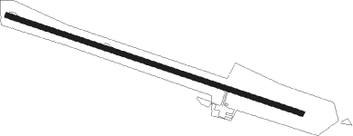
Runway info
| Runway 11 / 29 | ||
| length | 1115m (3658ft) | |
| bearing | 102° / 282° | |
| width | 18m (59ft) | |
| surface | asphalt | |
| displ threshold | 229m (751ft) / 34m (112ft) | |
Nearby beacons
| code | identifier | dist | bearing | frequency |
|---|---|---|---|---|
| PRI | PREVIK (PORI) VOR/DME | 23.9 | 311° | 113.20 |
| RUS | RUSKO (TURKU) VOR/DME | 36.1 | 175° | 115.50 |
Disclaimer
The information on this website is not for real aviation. Use this data with the X-Plane flight simulator only! Data taken with kind consent from X-Plane 12 source code and data files. Content is subject to change without notice.