Oripää
Airport details
| Country | Finland |
| State | Western Finland |
| Region | EF |
| Airspace | Helsinki Ctr |
| Municipality | Oripää |
| Elevation | 331ft (101m) |
| Timezone | GMT +2 |
| Coordinates | 60.87639, 22.74472 |
| Magnetic var | |
| Type | land |
| Available since | X-Plane v10.40 |
| ICAO code | EFOP |
| IATA code | n/a |
| FAA code | n/a |
Communication
| Oripää CTAF | 123.200 |
Nearby Points of Interest:
Teineinkivi
-Virttaa Church
-Tontereenmäki
-Kyrö railway station
-Pirttiniemennokka
-Aurajoen ratasilta
-Käyrä prison
-Huittinen Church
-Halkivahankivi
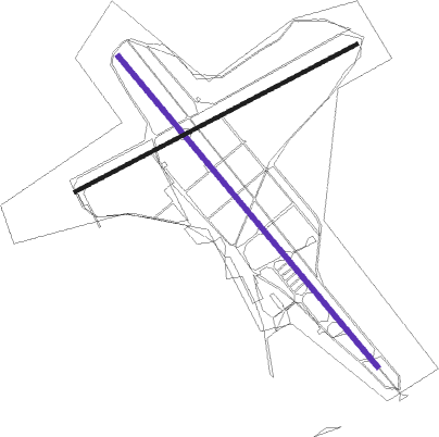
Runway info
| Runway 14 / 32 | ||
| length | 1199m (3934ft) | |
| bearing | 124° / 304° | |
| width | 15m (49ft) | |
| surface | asphalt | |
| displ threshold | 132m (433ft) / 180m (591ft) | |
Runway 06 / 24  | ||
| length | 941m (3087ft) | |
| bearing | 78° / 258° | |
| width | 10m (33ft) | |
| surface | asphalt | |
Nearby beacons
| code | identifier | dist | bearing | frequency |
|---|---|---|---|---|
| RUS | RUSKO (TURKU) VOR/DME | 26 | 234° | 115.50 |
| PIR | PIRKKA (TAMPERE) VOR/DME | 40.1 | 57° | 116.20 |
| PRI | PREVIK (PORI) VOR/DME | 44.7 | 302° | 113.20 |
Disclaimer
The information on this website is not for real aviation. Use this data with the X-Plane flight simulator only! Data taken with kind consent from X-Plane 12 source code and data files. Content is subject to change without notice.