Pori
Airport details
| Country | Finland |
| State | Western Finland |
| Region | EF |
| Airspace | Helsinki Ctr |
| Municipality | Pori |
| Elevation | 42ft (13m) |
| Timezone | GMT +2 |
| Coordinates | 61.46139, 21.79778 |
| Magnetic var | |
| Type | land |
| Available since | X-Plane v10.40 |
| ICAO code | EFPO |
| IATA code | POR |
| FAA code | n/a |
Communication
| Pori ATIS | 113.200 |
| Pori Tower | 119.700 |
| Pori Tower | 119.250 |
| Pori Approach | 128.650 |
Approach frequencies
| ILS-cat-I | RW30 | 108.1 | 18.00mi |
| 3° GS | RW30 | 108.1 | 18.00mi |
Nearby Points of Interest:
Päärnäinen
-Stone-Pori
-Anola Manor
-Satalinna hospital
-Mäntyluoto railway station
-Reposaari
-Ahlainen village
-Kappelinluoto
-Emil Cedercreutz Museum
-Matinharju
-Kiukainen Church
-Kokemäki Castle
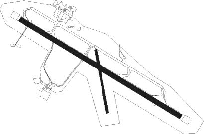
Runway info
Runway 12 / 30  | ||
| length | 2345m (7694ft) | |
| bearing | 109° / 289° | |
| width | 60m (197ft) | |
| surface | asphalt | |
| displ threshold | 95m (312ft) / 345m (1132ft) | |
| Runway 17 / 35 | ||
| length | 799m (2621ft) | |
| bearing | 167° / 347° | |
| width | 30m (98ft) | |
| surface | asphalt | |
| blast zone | 236m (774ft) / 175m (574ft) | |
Nearby beacons
| code | identifier | dist | bearing | frequency |
|---|---|---|---|---|
| PRI | PREVIK (PORI) VOR/DME | 0.2 | 329° | 113.20 |
| RUS | RUSKO (TURKU) VOR/DME | 58.3 | 154° | 115.50 |
Departure and arrival routes
| Transition altitude | 5000ft |
| STAR starting points | distance | inbound heading | |
|---|---|---|---|
| RW12 | |||
| NIFO1A | 19.5 | 25° | |
| KEFA1A | 19.8 | 75° | |
| ROGT3A | 23.8 | 92° | |
| OSDI3A | 15.8 | 213° | |
| XORM3A | 25.8 | 279° | |
| IDNI3A | 23.6 | 323° | |
| RW30 | |||
| NIFO1B | 19.5 | 25° | |
| KEFA1B | 19.8 | 75° | |
| ROGT3B | 23.8 | 92° | |
| OSDI4B | 15.8 | 213° | |
| XORM3B | 25.8 | 279° | |
| IDNI3B | 23.6 | 323° | |
Instrument approach procedures
| runway | airway (heading) | route (dist, bearing) |
|---|---|---|
| RW12 | MABOM (95°) | MABOM 2200ft REPLU (5mi, 56°) 2200ft |
| RW12 | REPLU (109°) | REPLU 2200ft |
| RW12 | VANOT (131°) | VANOT 2200ft REPLU (5mi, 236°) 2200ft |
| RNAV | REPLU 2200ft XENPO (5mi, 109°) 2000ft EFPO (6mi, 109°) 94ft ULVIS (10mi, 109°) 2200ft | |
| RW30 | PIBIR (275°) | PIBIR 2200ft ULVIS (5mi, 237°) 2200ft |
| RW30 | TUXEL (311°) | TUXEL 2200ft ULVIS (5mi, 57°) 2200ft |
| RW30 | ULVIS (289°) | ULVIS 2200ft |
| RNAV | ULVIS 2200ft ASBUD (5mi, 289°) 1700ft EFPO (6mi, 289°) 85ft REPLU (11mi, 289°) 2200ft |
Holding patterns
| STAR name | hold at | type | turn | heading* | altitude | leg | speed limit |
|---|---|---|---|---|---|---|---|
| IDNI3A | REPLU | VHF | right | 297 (117)° | > 2200ft | 1.0min timed | 230 |
| IDNI3B | ULVIS | VHF | right | 208 (28)° | > 2200ft | 1.0min timed | 230 |
| KEFA1A | REPLU | VHF | right | 297 (117)° | > 2200ft | 1.0min timed | 230 |
| KEFA1B | ULVIS | VHF | right | 208 (28)° | > 2200ft | 1.0min timed | 230 |
| NIFO1A | REPLU | VHF | right | 297 (117)° | > 2200ft | 1.0min timed | 230 |
| NIFO1B | ULVIS | VHF | right | 208 (28)° | > 2200ft | 1.0min timed | 230 |
| OSDI3A | REPLU | VHF | right | 297 (117)° | > 2200ft | 1.0min timed | 230 |
| OSDI4B | ULVIS | VHF | right | 208 (28)° | > 2200ft | 1.0min timed | 230 |
| ROGT3A | REPLU | VHF | right | 297 (117)° | > 2200ft | 1.0min timed | 230 |
| ROGT3B | ULVIS | VHF | right | 208 (28)° | > 2200ft | 1.0min timed | 230 |
| XORM3A | REPLU | VHF | right | 297 (117)° | > 2200ft | 1.0min timed | 230 |
| XORM3B | ULVIS | VHF | right | 208 (28)° | > 2200ft | 1.0min timed | 230 |
| *) magnetic outbound (inbound) holding course | |||||||
Disclaimer
The information on this website is not for real aviation. Use this data with the X-Plane flight simulator only! Data taken with kind consent from X-Plane 12 source code and data files. Content is subject to change without notice.