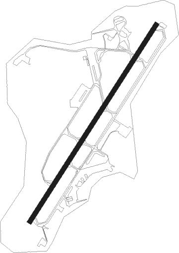
Rovaniemi
Airport details
| Country | Finland |
| State | Lapland |
| Region | EF |
| Airspace | Helsinki Ctr |
| Municipality | Rovaniemi |
| Elevation | 645ft (197m) |
| Timezone | GMT +2 |
| Coordinates | 66.56100, 25.83336 |
| Magnetic var | |
| Type | land |
| Available since | X-Plane v10.40 |
| ICAO code | EFRO |
| IATA code | RVN |
| FAA code | n/a |
Communication
| Rovaniemi Ground Control | 118.525 |
| Rovaniemi Tower | 118.700 |
| Rovaniemi Approach | 118.600 |
Approach frequencies
| ILS-cat-II | RW21 | 111.7 | 18.00mi |
| 3° GS | RW21 | 111.7 | 18.00mi |
Nearby beacons
| code | identifier | dist | bearing | frequency |
|---|---|---|---|---|
| ROI | ROVANI (ROVANIEMI) VOR/DME | 0.3 | 277° | 117.70 |
Departure and arrival routes
| Transition altitude | 5000ft |
| SID end points | distance | outbound heading | |
|---|---|---|---|
| RW03 | |||
| ROTK3B | 24mi | 18° | |
| MARX1B | 22mi | 87° | |
| ARFU1B | 19mi | 114° | |
| RENV3B | 30mi | 212° | |
| NEPI3B | 32mi | 237° | |
| OLNO3B | 35mi | 252° | |
| NEMG3B | 30mi | 259° | |
| IBSA3B | 21mi | 280° | |
| RW21 | |||
| ROTK3A | 24mi | 18° | |
| MARX1A | 22mi | 87° | |
| ARFU1A | 19mi | 114° | |
| RENV3A | 30mi | 212° | |
| NEPI3A | 32mi | 237° | |
| OLNO3A | 35mi | 252° | |
| NEMG3A | 30mi | 259° | |
| IBSA3A | 21mi | 280° | |
| STAR starting points | distance | inbound heading | |
|---|---|---|---|
| RW03 | |||
| RENV2D | 30.0 | 32° | |
| NEPI2D | 32.1 | 57° | |
| NEMG2D | 30.3 | 79° | |
| OSLI2D | 20.7 | 125° | |
| ROTK2D | 24.1 | 198° | |
| MARX1D | 22.0 | 267° | |
| ARFU1D | 19.4 | 294° | |
| RW21 | |||
| RENV2C | 30.0 | 32° | |
| NEPI2C | 32.1 | 57° | |
| NEMG2C | 30.3 | 79° | |
| OSLI2C | 20.7 | 125° | |
| ROTK2C | 24.1 | 198° | |
| MARX1C | 22.0 | 267° | |
| ARFU1C | 19.4 | 294° | |
Instrument approach procedures
| runway | airway (heading) | route (dist, bearing) |
|---|---|---|
| RW03 | MIPGO (78°) | MIPGO 2500ft ROPOV (5mi, 107°) 2500ft |
| RW03 | OTGUS (30°) | OTGUS 2500ft ROPOV (5mi, 287°) 2500ft |
| RW03 | ROPOV (63°) | ROPOV 2500ft |
| RNAV | ROPOV 2500ft UNUKA (5mi, 62°) 2400ft EFRO (6mi, 64°) 684ft RO364 (3mi, 59°) VEKIP (9mi, 9°) 2500ft | |
| RW21 | NIPAK (242°) | NIPAK 2500ft |
| RW21 | TUTUT (258°) | TUTUT 2500ft NIPAK (5mi, 287°) 2500ft |
| RW21 | VEKIP (207°) | VEKIP 2500ft NIPAK (5mi, 107°) 2500ft |
| RNAV | NIPAK 2500ft INSAR (4mi, 243°) 2400ft EFRO (6mi, 241°) 662ft ROPOV (11mi, 243°) 2500ft |
Holding patterns
| STAR name | hold at | type | turn | heading* | altitude | leg | speed limit |
|---|---|---|---|---|---|---|---|
| ARFU1C | NIPAK | VHF | right | 25 (205)° | > 2500ft | 1.0min timed | 230 |
| ARFU1D | ROPOV | VHF | left | 205 (25)° | > 2500ft | 1.0min timed | 230 |
| MARX1C | NIPAK | VHF | right | 25 (205)° | > 2500ft | 1.0min timed | 230 |
| MARX1D | ROPOV | VHF | left | 205 (25)° | > 2500ft | 1.0min timed | 230 |
| NEMG2C | VEKIP | VHF | left | 205 (25)° | > 2500ft | 1.0min timed | 230 |
| NEMG2D | ROPOV | VHF | left | 205 (25)° | > 2500ft | 1.0min timed | 230 |
| NEPI2C | VEKIP | VHF | left | 205 (25)° | > 2500ft | 1.0min timed | 230 |
| NEPI2D | ROPOV | VHF | left | 205 (25)° | > 2500ft | 1.0min timed | 230 |
| OSLI2C | VEKIP | VHF | left | 205 (25)° | > 2500ft | 1.0min timed | 230 |
| OSLI2D | ROPOV | VHF | left | 205 (25)° | > 2500ft | 1.0min timed | 230 |
| RENV2C | NIPAK | VHF | right | 25 (205)° | > 2500ft | 1.0min timed | 230 |
| RENV2D | ROPOV | VHF | left | 205 (25)° | > 2500ft | 1.0min timed | 230 |
| ROTK2C | NIPAK | VHF | right | 25 (205)° | > 2500ft | 1.0min timed | 230 |
| ROTK2D | ROPOV | VHF | left | 205 (25)° | > 2500ft | 1.0min timed | 230 |
| *) magnetic outbound (inbound) holding course | |||||||
Disclaimer
The information on this website is not for real aviation. Use this data with the X-Plane flight simulator only! Data taken with kind consent from X-Plane 12 source code and data files. Content is subject to change without notice.