Doddington - Chatteris
Airport details
| Country | United Kingdom |
| State | England |
| Region | |
| Airspace | London Ctr |
| Municipality | Cambridgeshire |
| Elevation | 3ft (1m) |
| Timezone | GMT +0 |
| Coordinates | 52.48514, 0.08904 |
| Magnetic var | |
| Type | land |
| Available since | X-Plane v10.40 |
| ICAO code | EG17 |
| IATA code | n/a |
| FAA code | n/a |
Communication
Nearby Points of Interest:
Town Hall
-Ramsey Abbey
-Adventurers' Land
-Ramsey Abbey Gatehouse
-Bishop's Palace Bishop's Palace (the Palace School)
-Woodwalton Fen
-Old Town Hall
-Leverington Hall
-Spinney Abbey
-The Manor
-Ryston Hall
-Peterscourt
-Old Guild Hall
-Old Bridge, Huntingdon
-Ingleborough Tower Windmill
-Farm Hall
-Hinchingbrooke House
-Thorpe Hall
-Crimplesham Hall
-Milton Hall
-Quy Hall
-Chesterton Hall
-Winnold House
-Pepys Library
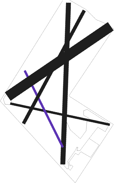
Runway info
Runway 01 / 19  | ||
| length | 610m (2001ft) | |
| bearing | 11° / 191° | |
| width | 18m (59ft) | |
| surface | grass | |
| Runway 6 / 24 | ||
| length | 444m (1457ft) | |
| bearing | 71° / 251° | |
| width | 38m (125ft) | |
| surface | grass | |
| Runway 3 / 21 | ||
| length | 486m (1594ft) | |
| bearing | 46° / 226° | |
| width | 12m (39ft) | |
| surface | grass | |
| Runway 10 / 28 | ||
| length | 386m (1266ft) | |
| bearing | 100° / 280° | |
| width | 8m (26ft) | |
| surface | grass | |
| Runway 15 / 33 | ||
| length | 324m (1063ft) | |
| bearing | 147° / 327° | |
| width | 8m (26ft) | |
| surface | grass | |
Nearby beacons
| code | identifier | dist | bearing | frequency |
|---|---|---|---|---|
| MLD | MILDENHALL TACAN | 16.3 | 107° | 115.90 |
| CAM | CAMBRIDGE NDB | 16.8 | 161° | 332 |
| LKH | LAKENHEATH TACAN | 17.4 | 100° | 110.20 |
| MAM | MARHAM TACAN | 19.7 | 71° | 108.70 |
| WIT | WITTERING TACAN | 22.6 | 282° | 117.60 |
| BKY | BARKWAY VOR/DME | 29.7 | 183° | 116.25 |
| CIT | CRANFIELD NDB | 31.8 | 241° | 850 |
| CGY | CONINGSBY TACAN | 37.5 | 337° | 111.10 |
| LUT | LUTON NDB | 37.6 | 210° | 345 |
| WTZ | WATTISHAM TACAN | 38.1 | 113° | 109.30 |
| CWL | CRANWELL NDB | 38.7 | 313° | 423 |
| CWZ | CRANWELL TACAN | 38.7 | 313° | 117.40 |
| LE | LEICESTER NDB | 41.6 | 276° | 383 |
| BPK | BROOKMANS PARK VOR/DME | 44.7 | 195° | 117.50 |
| WAD | WADDINGTON TACAN | 46.5 | 318° | 117.10 |
| LAM | LAMBOURNE VOR/DME | 50.4 | 176° | 115.60 |
| BNN | BOVINGDON VOR/DME | 51.3 | 220° | 113.75 |
| WCO | WESTCOTT NDB | 54.2 | 239° | 335 |
| HEN | HENTON NDB | 54.3 | 230° | 433 |
| CHT | CHILTERN NDB | 56.4 | 215° | 277 |
| LCY | LONDON CITY NDB | 58.9 | 181° | 322 |
| SND | SOUTHEND NDB | 59 | 146° | 362 |
| GAM | GAMSTON VOR/DME | 60.8 | 308° | 112.80 |
| LON | LONDON VOR/DME | 63.3 | 209° | 113.60 |
| BUR | BURNHAM NDB | 64.5 | 218° | 421 |
| FNY | DONCASTER SHEFFIELD NDB | 71.3 | 312° | 338 |
Disclaimer
The information on this website is not for real aviation. Use this data with the X-Plane flight simulator only! Data taken with kind consent from X-Plane 12 source code and data files. Content is subject to change without notice.