Airports for X-Plane offers a convenient way to explore airports and their related communication information for the X-Plane flight simulator. It only uses data from the X-Plane flight simulator itself, and is therefore more reliable than the data that comes from real aviation websites. You can search for airports by using the ICAO code, or browse for airports per country and state. The information displayed is categorized by airport details, runway information, airport communication, approach frequencies (ILS and Glidepath details), details of nearby beacons, SIDs, STARs and approach procedures.

immigration luggage propeller plane airplane customs jet rail transport plane jetliner takeoff railway station airline flown flight attendant ferry regional airport authority aerodromes airspace field

Langar - East Fortune

Airport details

CountryUnited Kingdom
StateScotland
RegionEG
AirspaceScottish Ctr
MunicipalityEast Lothian
Elevation120ft (37m)
TimezoneGMT +0
Coordinates56.00032, -2.73594
Magnetic var
Typeland
Available sinceX-Plane v10.40
ICAO codeEG32
IATA coden/a
FAA coden/a

Communication

East Fortune East Fortune Radio118.755
Nearby Points of Interest:
Gilmerton House
-
RAF East Fortune
-
Garleton Castle
-
Ballencrieff Castle
-
Traprain Law
-
Haddington, Court Street, Town House
-
Haddington, 27 Sidegate Street, Haddington House
-
Whitekirk, Parish Church
-
Luffness Castle
-
Greywalls
-
Yellowcraig
-
Tyninghame House
-
Whittingehame Tower
-
Whittingehame House
-
Yester House
-
Yester Chapel
-
White Castle Fort,settlement 500m NW of,Fallow Green Rig
-
Bowerhouse
-
Saltoun Hall
-
Dunbar, Friarscroft
-
Dunbar, High Street, Town House
-
Winton House
-
Spott House
-
Tranent Tower
-
Hopes House

Runway info

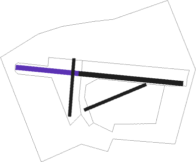
Runway 07 / 25  
 length174m (571ft)
 bearing80° / 260°
 width8m (26ft)
 surfacegrass
Runway 10 / 28
 length173m (568ft)
 bearing96° / 276°
 width12m (39ft)
 surfacegrass
Runway 11 / 29  
 length272m (892ft)
 bearing96° / 276°
 width12m (39ft)
 surfaceconcrete
 displ threshold0m (0ft) / 52m (171ft)
Runway 03 / 21  
 length150m (492ft)
 bearing16° / 196°
 width8m (26ft)
 surfacegrass

Airport layout - runway 10 / 28


Nearby beacons

codeidentifierdistbearingfrequency
EDNEDINBURGH NDB18.5268°341
SABSAINT ABBS VOR/DME18.6100°112.50
LUKLEUCHARS TACAN22.7341°110.50
UWEDINBURGH NDB26.4263°368
DNDDUNDEE NDB30320°394
PTHPERTH VOR33.9305°110.40
TLATALLA VOR/DME36.6231°113.80

Disclaimer

The information on this website is not for real aviation. Use this data with the X-Plane flight simulator only! Data taken with kind consent from X-Plane 12 source code and data files. Content is subject to change without notice.