Belfast - Belfast Aldergrove
Airport details
| Country | United Kingdom |
| State | Northern Ireland |
| Region | EG |
| Airspace | Scottish Ctr |
| Municipality | County Antrim |
| Elevation | 268ft (82m) |
| Timezone | GMT +0 |
| Coordinates | 54.65437, -6.21925 |
| Magnetic var | |
| Type | land |
| Available since | X-Plane v10.40 |
| ICAO code | EGAA |
| IATA code | BFS |
| FAA code | n/a |
Communication
| Belfast Aldergrove ATIS | 126.130 |
| Belfast Aldergrove Tower | 118.300 |
| Belfast Aldergrove DIRECTOR | 120.900 |
| Belfast Aldergrove Approach | 128.500 |
| Belfast Aldergrove Tower Departure | 118.300 |
Approach frequencies
| ILS-cat-III | RW25 | 109.9 | 18.00mi |
| ILS-cat-I | RW17 | 110.9 | 18.00mi |
| 3° GS | RW25 | 109.9 | 18.00mi |
| 3° GS | RW17 | 110.9 | 18.00mi |
Nearby Points of Interest:
Carrickfergus Borough Council Town Hall Joymount Carrickfergus Co. Antrim Bt38 7dl
-Town Hall Upper Cross Street Larne Co Antrim Bt40 1sz
-Banbridge Town Hall
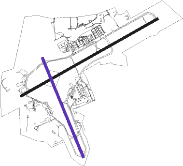
Runway info
Runway 07 / 25  | ||
| length | 2782m (9127ft) | |
| bearing | 75° / 255° | |
| width | 45m (148ft) | |
| surface | asphalt | |
| blast zone | 59m (194ft) / 48m (157ft) | |
| Runway 17 / 35 | ||
| length | 1890m (6201ft) | |
| bearing | 151° / 331° | |
| width | 45m (148ft) | |
| surface | asphalt | |
| displ threshold | 0m (0ft) / 91m (299ft) | |
| blast zone | 56m (184ft) / 31m (102ft) | |
Nearby beacons
| code | identifier | dist | bearing | frequency |
|---|---|---|---|---|
| BEL | BELFAST VOR/DME | 0.5 | 303° | 117.20 |
| OY | BELFAST/ALDERGROVE NDB | 5.1 | 74° | 332 |
| HB | BELFAST CITY NDB | 12.2 | 95° | 420 |
| EGT | LONDONDERRY NDB | 40 | 293° | 328 |
| CBL | CAMPBELTOWN NDB | 50.3 | 34° | 380 |
| MAC | MACHRIHANISH VOR/DME | 50.5 | 36° | 116 |
| MCM | DME | 50.6 | 223° | 114.40 |
Instrument approach procedures
| runway | airway (heading) | route (dist, bearing) |
|---|---|---|
| RW07 | LIRGU (56°) | LIRGU 4000ft AA07I (5mi, 321°) 2500ft |
| RW07 | SULEV (90°) | SULEV 4000ft AA07I (5mi, 141°) 2500ft |
| RW07 | VAGMO (75°) | VAGMO 4000ft AA07I (5mi, 75°) 2500ft |
| RNAV | AA07I 2500ft AA07F (3mi, 75°) 2500ft EGAA (8mi, 75°) 256ft (3297mi, 174°) 1200ft (turn) 3000ft BEL (3297mi, 353°) 3000ft |
Disclaimer
The information on this website is not for real aviation. Use this data with the X-Plane flight simulator only! Data taken with kind consent from X-Plane 12 source code and data files. Content is subject to change without notice.