Leicester
Airport details
| Country | United Kingdom |
| State | England |
| Region | EG |
| Airspace | London Ctr |
| Municipality | Harborough District |
| Elevation | 469ft (143m) |
| Timezone | GMT +0 |
| Coordinates | 52.60778, -1.03194 |
| Magnetic var | |
| Type | land |
| Available since | X-Plane v10.40 |
| ICAO code | EGBG |
| IATA code | n/a |
| FAA code | n/a |
Communication
| Leicester Leicester Radio | 122.125 |
| Leicester unnamed entity | 128.800 |
Nearby Points of Interest:
Scraptoft Hall
-Carlton Curlieu Hall
-Towers Hospital Blocks 29, 30, 36, 37, 38, 39, 40, And 41
-Arch of Remembrance
-Fielding Johnson Building
-Quenby Hall
-Turkey Cafe
-Leicester Town Hall
-Church of St Mark
-Leicester Castle
-Baggrave Hall
-Skeffington Hall
-Noseley Hall
-Lowesby Hall
-Red Hill filling station
-Ashby Folville Manor
-Gaddesby Hall
-Narborough Hall
-Launde Abbey
-Groby Old Hall
-Brooksby Hall
-Groby Castle
-Swithland Hall
-Mountsorrel Cross
-The Tower House, Lubenham
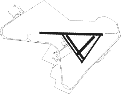
Runway info
Runway 15 / 33  | ||
| length | 494m (1621ft) | |
| bearing | 136° / 316° | |
| width | 18m (59ft) | |
| surface | asphalt | |
| Runway 04 / 22 | ||
| length | 492m (1614ft) | |
| bearing | 53° / 233° | |
| width | 18m (59ft) | |
| surface | asphalt | |
| Runway 06 / 24 | ||
| length | 352m (1155ft) | |
| bearing | 61° / 241° | |
| width | 38m (125ft) | |
| surface | grass | |
| Runway 16 / 34 | ||
| length | 422m (1385ft) | |
| bearing | 136° / 316° | |
| width | 30m (98ft) | |
| surface | grass | |
| Runway 10 / 28 | ||
| length | 930m (3051ft) | |
| bearing | 94° / 274° | |
| width | 30m (98ft) | |
| surface | asphalt | |
Nearby beacons
| code | identifier | dist | bearing | frequency |
|---|---|---|---|---|
| LE | LEICESTER NDB | 0.1 | 246° | 383 |
| EME | EAST MIDLANDS NDB | 14.7 | 324° | 353 |
| WIT | WITTERING TACAN | 19.4 | 90° | 117.60 |
| EMW | EAST MIDLANDS NDB | 20.3 | 298° | 393 |
| DTY | DAVENTRY VOR/DME | 25.8 | 191° | 116.40 |
| HON | HONILEY VOR/DME | 27.5 | 248° | 113.65 |
| BHX | BIRMINGHAM NDB | 27.8 | 258° | 406 |
| TNL | TATENHILL NDB | 29.4 | 286° | 327 |
| CWL | CRANWELL NDB | 31.9 | 52° | 423 |
| CWZ | CRANWELL TACAN | 32.1 | 52° | 117.40 |
| CIT | CRANFIELD NDB | 33.5 | 135° | 850 |
| TNT | TRENT VOR/DME | 35.4 | 305° | 115.70 |
| WAD | WADDINGTON TACAN | 38.1 | 42° | 117.10 |
| GAM | GAMSTON VOR/DME | 40.5 | 7° | 112.80 |
| CGY | CONINGSBY TACAN | 42.6 | 61° | 111.10 |
| WCO | WESTCOTT NDB | 45.4 | 175° | 335 |
| OX | OXFORD NDB | 47.7 | 201° | 367 |
| CAM | CAMBRIDGE NDB | 50.4 | 108° | 332 |
| LUT | LUTON NDB | 51.5 | 132° | 345 |
| HEN | HENTON NDB | 51.7 | 164° | 433 |
| FNY | DONCASTER SHEFFIELD NDB | 52 | 2° | 338 |
| BKY | BARKWAY VOR/DME | 54.6 | 119° | 116.25 |
| BZ | BRIZE NORTON NDB | 55.6 | 214° | 386 |
| BZN | BRIZE NORTON TACAN | 55.7 | 214° | 111.90 |
| BNN | BOVINGDON VOR/DME | 55.8 | 151° | 113.75 |
| MLD | MILDENHALL TACAN | 57.5 | 99° | 115.90 |
| MAM | MARHAM TACAN | 58.1 | 89° | 108.70 |
| LKH | LAKENHEATH TACAN | 59 | 97° | 110.20 |
| BSO | BENSON TACAN | 59.6 | 184° | 110 |
| BPK | BROOKMANS PARK VOR/DME | 61.7 | 133° | 117.50 |
| CHT | CHILTERN NDB | 62 | 152° | 277 |
| FFA | FAIRFORD TACAN | 62.3 | 220° | 113.40 |
| KIM | HUMBERSIDE NDB | 62.9 | 35° | 365 |
| LAM | LAMBOURNE VOR/DME | 72.3 | 129° | 115.60 |
Disclaimer
The information on this website is not for real aviation. Use this data with the X-Plane flight simulator only! Data taken with kind consent from X-Plane 12 source code and data files. Content is subject to change without notice.