Caernarfon
Airport details
| Country | United Kingdom |
| State | Wales |
| Region | EG |
| Airspace | London Ctr |
| Municipality | Gwynedd |
| Elevation | 0ft (0m) |
| Timezone | GMT +0 |
| Coordinates | 53.10114, -4.33535 |
| Magnetic var | |
| Type | land |
| Available since | X-Plane v10.32 |
| ICAO code | EGCK |
| IATA code | n/a |
| FAA code | n/a |
Communication
| Caernarfon Caernarfon Radio | 122.255 |
Nearby Points of Interest:
St Baglan's Church
-River Seiont
-Caernarfon town walls
-Royal Welsh Yacht Club
-Caernarfon Barracks
-Cwningar Niwbwrch - Ynys Llanddwyn
-Old Church of St Nidan, Llanidan
-Bryn Bras Castle
-Melin Hermon
-Malltraeth Marsh
-Llyn Padarn
-St Cwyfan's Church
-Melin Sguthan
-Capel Horeb
-Dinorwic Slate Quarry Workshops
-St Ceinwen's Church
-St Michael's Church, Llanfihangel Ysgeifiog
-St Mary's Church, Tal-y-llyn
-St Mary's Church
-County Court
-Moreia Chapel
-Ystumcegid
-Llangefni Town Hall
-Rayner Memorial Clock Tower
-Menai Suspension Bridge
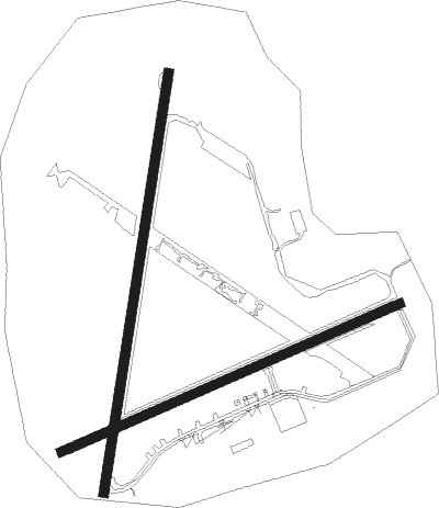
Runway info
Runway 07 / 25  | ||
| length | 928m (3045ft) | |
| bearing | 78° / 258° | |
| width | 23m (75ft) | |
| surface | asphalt | |
| displ threshold | 97m (318ft) / 167m (548ft) | |
| Runway 02 / 20 | ||
| length | 1066m (3497ft) | |
| bearing | 21° / 201° | |
| width | 23m (75ft) | |
| surface | asphalt | |
| displ threshold | 77m (253ft) / 0m (0ft) | |
Nearby beacons
| code | identifier | dist | bearing | frequency |
|---|---|---|---|---|
| VYL | VALLEY TACAN | 11.6 | 305° | 108.40 |
| RWY | RONALDSWAY NDB | 59.7 | 344° | 359 |
| IOM | ISLE OF MAN VOR/DME | 59.9 | 336° | 112.20 |
Disclaimer
The information on this website is not for real aviation. Use this data with the X-Plane flight simulator only! Data taken with kind consent from X-Plane 12 source code and data files. Content is subject to change without notice.