Lyneham - Raf Lyneham
Airport details
| Country | United Kingdom |
| State | England |
| Region | EG |
| Airspace | London Ctr |
| Municipality | Wiltshire |
| Elevation | 513ft (156m) |
| Timezone | GMT +0 |
| Coordinates | 51.50515, -1.99343 |
| Magnetic var | |
| Type | land |
| Available since | X-Plane v10.40 |
| ICAO code | EGDL |
| IATA code | LYE |
| FAA code | n/a |
Communication
| RAF Lyneham SafetyCom | 135.480 |
Nearby Points of Interest:
Bradenstoke Priory
-St James's Church, Draycot Cerne
-Town Hall
-The Yelde Hall And The Council Chamber
-best western plus angel hotel
-Chippenham Town Hall
-Bincknoll Castle
-Malmesbury Market Cross
-Bolehyde Manor
-Charlton Park
-Beckhampton Avenue
-King's Play Hill
-Sheldon Manor
-Lacock Abbey
-Battle of Roundway Down
-Sevington Victorian School
-The Spectrum Building (formerly The Renault Distribution Centre)
-Grittleton House
-The Bath House
-Corsham Court
-Hungerford Almshouses
-Hartham Park
-Swindon Town Hall
-Corn Exchange And Town Hall
-Burderop Park
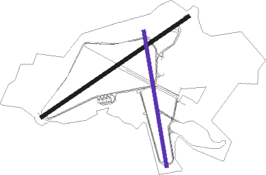
Runway info
Runway 06 / 24  | ||
| length | 2380m (7808ft) | |
| bearing | 70° / 250° | |
| width | 46m (151ft) | |
| surface | asphalt | |
| displ threshold | 0m (0ft) / 177m (581ft) | |
| Runway 18 / 36 | ||
| length | 1826m (5991ft) | |
| bearing | 172° / 352° | |
| width | 46m (151ft) | |
| surface | asphalt | |
| displ threshold | 6m (20ft) / 6m (20ft) | |
Nearby beacons
| code | identifier | dist | bearing | frequency |
|---|---|---|---|---|
| FFA | FAIRFORD TACAN | 12.8 | 48° | 113.40 |
| BZN | BRIZE NORTON TACAN | 20.6 | 58° | 111.90 |
| BZ | BRIZE NORTON NDB | 20.7 | 58° | 386 |
| OF | FILTON NDB | 22.3 | 272° | 325 |
| BDN | BOSCOMBE DOWN TACAN | 23.2 | 146° | 108.20 |
| GST | GLOUCESTERSHIRE NDB | 24.1 | 336° | 331 |
| BRI | BRISTOL NDB | 28.1 | 260° | 414 |
| CPT | COMPTON VOR/DME | 28.9 | 91° | 114.35 |
| OX | OXFORD NDB | 31.8 | 64° | 367 |
| BSO | BENSON TACAN | 34 | 83° | 110 |
| VLN | YEOVILTON TACAN | 38.6 | 232° | 111 |
| EAS | SOUTHAMPTON (EASTLEIGH) NDB | 40.8 | 131° | 391 |
| SAM | SOUTHAMPTON VOR/DME | 41 | 130° | 113.35 |
| YVL | DME | 42 | 229° | 109.05 |
| YVL | YEOVIL NDB | 42.2 | 230° | 343 |
| BIA | BOURNEMOUTH NDB | 44 | 168° | 339 |
| DTY | DAVENTRY VOR/DME | 52 | 52° | 116.40 |
| HON | HONILEY VOR/DME | 52.5 | 21° | 113.65 |
| SH | SHOBDON NDB | 55.1 | 310° | 426 |
| BHX | BIRMINGHAM NDB | 57.7 | 14° | 406 |
Disclaimer
The information on this website is not for real aviation. Use this data with the X-Plane flight simulator only! Data taken with kind consent from X-Plane 12 source code and data files. Content is subject to change without notice.