Airports for X-Plane offers a convenient way to explore airports and their related communication information for the X-Plane flight simulator. It only uses data from the X-Plane flight simulator itself, and is therefore more reliable than the data that comes from real aviation websites. You can search for airports by using the ICAO code, or browse for airports per country and state. The information displayed is categorized by airport details, runway information, airport communication, approach frequencies (ILS and Glidepath details), details of nearby beacons, SIDs, STARs and approach procedures.

buildings near airspeed airport authority international air traffic control public transport port road jet airborne military drome airport terminal bus flight attendant stolport tarmac aerodromes international airport

Ilminster - Rnas Merryfield

Airport details

CountryUnited Kingdom
StateEngland
Region
AirspaceLondon Ctr
MunicipalitySouth Somerset
Elevation145ft (44m)
TimezoneGMT +0
Coordinates50.96240, -2.95209
Magnetic var
Typeland
Available sinceX-Plane v10.40
ICAO codeEGDW
IATA coden/a
FAA coden/a

Communication

No airport communication available for EGDW
Nearby Points of Interest:
Hatch Court
-
Earnshill House
-
Swell Court Farmhouse, Fivehead
-
Thurlbear Wood and Quarrylands
-
West Sedgemoor
-
Freshmoor
-
Ruttersleigh
-
Curry and Hay Moors
-
Midelney Manor
-
West Moor SSSI
-
Whitestaunton Manor
-
East Lambrook Manor
-
The Guildhall
-
Hinton House
-
Balt Moor Wall
-
Prior's Park & Adcombe Wood
-
Poundisford Park
-
St Margaret's Almshouses
-
Parrett Iron Works
-
Former Stuckey and Bagehot Warehouse
-
Gray's Almshouses, Taunton
-
Maunsel House
-
North Moor
-
Southlake Moor
-
Tudor House

Runway info

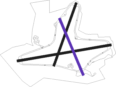
Runway 09 / 27  
 length1826m (5991ft)
 bearing87° / 267°
 width46m (151ft)
 surfaceasphalt
 displ threshold53m (174ft) / 0m (0ft)
Runway 03 / 21  
 length1274m (4180ft)
 bearing35° / 215°
 width46m (151ft)
 surfaceasphalt
Runway 16 / 34
 length1169m (3835ft)
 bearing152° / 332°
 width46m (151ft)
 surfaceasphalt
 displ threshold0m (0ft) / 110m (361ft)

Airport layout - runway 16 / 34


Parking locations

Nearby beacons

codeidentifierdistbearingfrequency
YVLYEOVIL NDB10.994°343
YVLDME11.394°109.05
VLNYEOVILTON TACAN12.182°111
EXEXETER NDB18.1238°337
BRIBRISTOL NDB26.629°414
CDFCARDIFF NDB29.6318°388
OFFILTON NDB36.133°325
BHDBERRY HEAD VOR/DME39.6224°112.05
BCNBRECON VOR/DME47.2338°117.45
GSTGLOUCESTERSHIRE NDB6340°331

Disclaimer

The information on this website is not for real aviation. Use this data with the X-Plane flight simulator only! Data taken with kind consent from X-Plane 12 source code and data files. Content is subject to change without notice.