North Ronaldsay
Airport details
| Country | United Kingdom |
| State | Scotland |
| Region | EG |
| Airspace | Scottish Ctr |
| Municipality | Orkney Islands |
| Elevation | 40ft (12m) |
| Timezone | GMT +0 |
| Coordinates | 59.36750, -2.43444 |
| Magnetic var | |
| Type | land |
| Available since | X-Plane v10.40 |
| ICAO code | EGEN |
| IATA code | NRL |
| FAA code | n/a |
Communication
Nearby Points of Interest:
North Ronaldsay, Sheep Dyke And Associated Punds
-chambered cairn on Vinquoy Hill
-Papa Westray, Holland House
-Holland Farm
-St Boniface Kirk (Papa Westray)
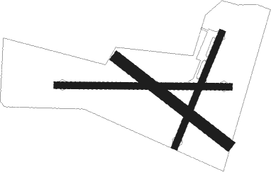
Runway info
Runway 10 / 28  | ||
| length | 466m (1529ft) | |
| bearing | 93° / 273° | |
| width | 18m (59ft) | |
| surface | gravel | |
| Runway 03 / 21 | ||
| length | 331m (1086ft) | |
| bearing | 45° / 225° | |
| width | 18m (59ft) | |
| surface | gravel | |
| displ threshold | 35m (115ft) / 39m (128ft) | |
| blast zone | 0m (0ft) / 3m (10ft) | |
| Runway 14 / 32 | ||
| length | 377m (1237ft) | |
| bearing | 115° / 295° | |
| width | 30m (98ft) | |
| surface | grass | |
| displ threshold | 33m (108ft) / 40m (131ft) | |
Nearby beacons
| code | identifier | dist | bearing | frequency |
|---|---|---|---|---|
| KWL | KIRKWALL VOR/DME | 28.2 | 228° | 108.60 |
| KW | KIRKWALL NDB | 28.3 | 229° | 395 |
| WIK | WICK VOR/DME | 58.3 | 216° | 113.60 |
| WCK | WICK NDB | 58.6 | 214° | 344 |
Disclaimer
The information on this website is not for real aviation. Use this data with the X-Plane flight simulator only! Data taken with kind consent from X-Plane 12 source code and data files. Content is subject to change without notice.