Haverfordwest
Airport details
| Country | United Kingdom |
| State | Wales |
| Region | EG |
| Airspace | London Ctr |
| Municipality | Pembrokeshire |
| Elevation | 159ft (48m) |
| Timezone | GMT +0 |
| Coordinates | 51.83306, -4.96111 |
| Magnetic var | |
| Type | land |
| Available since | X-Plane v10.40 |
| ICAO code | EGFE |
| IATA code | HAW |
| FAA code | n/a |
Communication
| Haverfordwest Haverfordwest Radio | 122.200 |
Nearby Points of Interest:
County of Pembroke War Memorial
-Wallis Moor
-Llawhaden Bridge
-Gelli Bridge
-Benton Castle
-Pill Priory
-St Thomas à Becket Chapel, Milford Haven
-St David's Church
-The Grove
-Fort Hubberstone
-Paterchurch Tower
-Upton Chapel
-Dockyard Chapel
-Esgyrn Bottom
-Temple Druid
-Rhydwilym Baptist Church
-Popton Fort
-Melin Tregwynt
-Great Castle Head Light
-Monkton Old Hall
-St Decuman's Church
-Pembroke Town Walls
-Preseli Hills
-Church Of St. Mary
-St Brides Castle
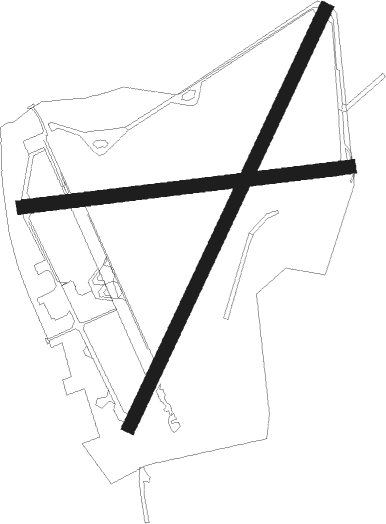
Runway info
Runway 09 / 27  | ||
| length | 1088m (3570ft) | |
| bearing | 88° / 268° | |
| width | 45m (148ft) | |
| surface | asphalt | |
| displ threshold | 228m (748ft) / 268m (879ft) | |
| Runway 03 / 21 | ||
| length | 1524m (5000ft) | |
| bearing | 43° / 223° | |
| width | 45m (148ft) | |
| surface | asphalt | |
| displ threshold | 221m (725ft) / 253m (830ft) | |
Nearby beacons
| code | identifier | dist | bearing | frequency |
|---|---|---|---|---|
| HAV | HAVERFORDWEST NDB | 0.2 | 260° | 328 |
| HDW | DME | 0.3 | 263° | 116.75 |
| STU | STRUMBLE VOR/DME | 10.1 | 334° | 113.10 |
Disclaimer
The information on this website is not for real aviation. Use this data with the X-Plane flight simulator only! Data taken with kind consent from X-Plane 12 source code and data files. Content is subject to change without notice.