Bembridge
Airport details
| Country | United Kingdom |
| State | England |
| Region | EG |
| Airspace | London Ctr |
| Municipality | Bembridge |
| Elevation | 55ft (17m) |
| Timezone | GMT +0 |
| Coordinates | 50.67800, -1.10950 |
| Magnetic var | |
| Type | land |
| Available since | X-Plane v10.40 |
| ICAO code | EGHJ |
| IATA code | BBP |
| FAA code | n/a |
Communication
| Bembridge Bembridge Radio | 123.250 |
Nearby Points of Interest:
Bembridge Down
-Yaverland Manor
-Nunwell House
-Morton Manor
-Sandown Barrack Battery
-Church of St. Michael and All Angels, Swanmore, Ryde
-Holy Trinity Church, Ryde
-Ryde Theatre and Town Hall
-Ryde Pier
-America Wood
-Haseley Manor
-HMS Invincible
-Arreton Manor
-Spitbank Fort
-Fort Monckton
-South Parade Pier
-Knight & Lee
-Square Tower
-Round Tower, Broad Street
-Browndown Battery
-God's Providence House, Newport
-Barton Manor, Whippingham
-Portsmouth War Memorial
-Fort Cumberland
-Saint Thomas of Canterbury church, Newport, Isle of Wight
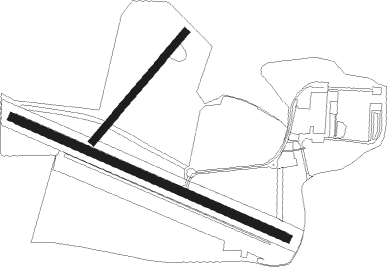
Runway info
Runway 05 / 23  | ||
| length | 394m (1293ft) | |
| bearing | 57° / 237° | |
| width | 21m (69ft) | |
| surface | grass | |
| Runway 12 / 30 | ||
| length | 832m (2730ft) | |
| bearing | 109° / 289° | |
| width | 23m (75ft) | |
| surface | concrete | |
| displ threshold | 61m (200ft) / 89m (292ft) | |
Nearby beacons
| code | identifier | dist | bearing | frequency |
|---|---|---|---|---|
| GWC | GOODWOOD VOR/DME | 17.1 | 63° | 114.75 |
| SAM | SOUTHAMPTON VOR/DME | 18.8 | 320° | 113.35 |
| EAS | SOUTHAMPTON (EASTLEIGH) NDB | 19 | 318° | 391 |
| BIA | BOURNEMOUTH NDB | 28.5 | 278° | 339 |
| MID | MIDHURST VOR/DME | 29.1 | 52° | 114 |
| SHM | SHOREHAM NDB | 32.3 | 79° | 332 |
| SRH | DME-ILS | 32.4 | 79° | 109.95 |
| ODH | ODIHAM TACAN | 33.8 | 16° | 109.60 |
| BDN | BOSCOMBE DOWN TACAN | 37.3 | 306° | 108.20 |
| BLC | DME | 40 | 22° | 116.20 |
| BLK | BLACKBUSHE NDB | 40 | 22° | 328 |
| OCK | OCKHAM VOR/DME | 45.2 | 47° | 115.30 |
| SFD | SEAFORD VOR/DME | 47 | 86° | 117 |
| WOD | WOODLEY NDB | 47.3 | 17° | 352 |
| EPM | EPSOM NDB | 47.5 | 49° | 316 |
| CPT | COMPTON VOR/DME | 49 | 352° | 114.35 |
| MAY | MAYFIELD VOR/DME | 50.7 | 75° | 117.90 |
| BUR | BURNHAM NDB | 53 | 27° | 421 |
| LON | LONDON VOR/DME | 54.3 | 38° | 113.60 |
| BSO | BENSON TACAN | 56.2 | 1° | 110 |
| CHT | CHILTERN NDB | 60.9 | 32° | 277 |
| HLS | DME | 72.5 | 75° | 115.95 |
| LSH | HEADCORN (LASHENDEN) NDB | 72.5 | 75° | 340 |
| DET | DETLING VOR/DME | 74.6 | 70° | 117.30 |
Disclaimer
The information on this website is not for real aviation. Use this data with the X-Plane flight simulator only! Data taken with kind consent from X-Plane 12 source code and data files. Content is subject to change without notice.