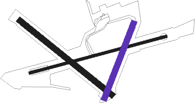
Saint Anne - Alderney
Airport details
| Country | Guernsey |
| State | Alderney |
| Region | EG |
| Airspace | Brest Ctr |
| Elevation | 291ft (89m) |
| Timezone | GMT +0 |
| Coordinates | 49.70676, -2.21448 |
| Magnetic var | |
| Type | land |
| Available since | X-Plane v10.30 |
| ICAO code | EGJA |
| IATA code | ACI |
| FAA code | n/a |
Communication
| Alderney Alderney Ground | 130.500 |
| Alderney Alderney Tower | 125.350 |
| Alderney Guernsey Approach | 128.650 |
Nearby Points of Interest:
Hague-Dick
-Chapelle du prieuré Saint-Hermel
-Camp du Castel
-Hôtel de ville de Cherbourg
-Hôtel Épron de la Horie
-Statue de Jean-François Millet, Cherbourg
-Corps de garde de Carteret
-Phare de Carteret
-Abbaye Notre-Dame de Grâce (Bricquebec, France)
Nearby beacons
| code | identifier | dist | bearing | frequency |
|---|---|---|---|---|
| ALD | ALDERNEY NDB | 0.5 | 82° | 383 |
| GUR | GUERNSEY VOR/DME | 22.1 | 235° | 109.40 |
| JSY | JERSEY VOR/DME | 29.8 | 161° | 112.20 |
| JW | JERSEY NDB | 30 | 181° | 329 |
| MP | CHERBOURG NDB | 32.9 | 95° | 373 |
Instrument approach procedures
| runway | airway (heading) | route (dist, bearing) |
|---|---|---|
| RW08 | AMOGA (101°) | AMOGA 2000ft ROGTO (5mi, 164°) 2000ft |
| RW08 | ELDUN (63°) | ELDUN 2000ft ROGTO (5mi, 344°) 2000ft |
| RNAV | ROGTO 2000ft JA08F (3mi, 83°) 2000ft EGJA (5mi, 83°) 324ft JAM01 (4mi, 83°) 690ft BANLO (8mi, 287°) 2000ft BANLO (turn) | |
| RW26 | TORVI (292°) | TORVI JAE02 (3mi, 29°) 2000ft GOKOD (2mi, 344°) 2000ft |
| RW26 | UNUKI (230°) | UNUKI 2000ft JAE01 (3mi, 127°) 2000ft GOKOD (2mi, 164°) 2000ft |
| RNAV | GOKOD 2000ft JA26F (3mi, 263°) 1500ft EGJA (4mi, 263°) 330ft JAM02 (3mi, 263°) 690ft BANLO (5mi, 357°) 2000ft BANLO (turn) |
Disclaimer
The information on this website is not for real aviation. Use this data with the X-Plane flight simulator only! Data taken with kind consent from X-Plane 12 source code and data files. Content is subject to change without notice.

