Redhill
Airport details
| Country | United Kingdom |
| State | England |
| Region | EG |
| Airspace | London Ctr |
| Municipality | Tandridge District |
| Elevation | 222ft (68m) |
| Timezone | GMT +0 |
| Coordinates | 51.21613, -0.14280 |
| Magnetic var | |
| Type | land |
| Available since | X-Plane v10.40 |
| ICAO code | EGKR |
| IATA code | KRH |
| FAA code | n/a |
Communication
| Redhill Redhill Information | 125.305 |
| Redhill Redhill Tower | 119.605 |
Nearby Points of Interest:
Wray Common Mill, Reigate
-Town Hall
-Charlwood House
-Beehive
-Barrow Green Court
-New Mill
-Woldingham & Oxted Downs
-Tree House
-Ancient Priors
-Friary Church of St Francis and St Anthony, Crawley
-Greathed Manor
-Purley Council Offices Including Attached Railings
-Juniper Hall
-Cherkley Court
-Broadfield House, Crawley
-Saint Hill Manor
-Milton Court
-Edenbridge Windmill
-Squerryes Court
-Bugby Chapel
-Stone Farm Rocks
-Broome Hall
-Wallington Town Hall
-Wesley House, With Steps And Walls To Front
-The Cock sign on Sutton High Street
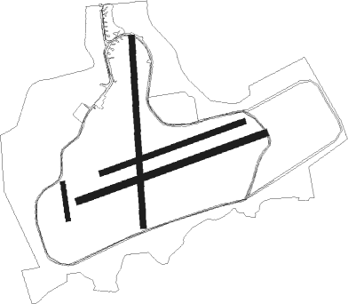
Runway info
Runway 08R / 26L  | ||
| length | 894m (2933ft) | |
| bearing | 80° / 260° | |
| width | 30m (98ft) | |
| surface | grass | |
| Runway 01 / 19 | ||
| length | 853m (2799ft) | |
| bearing | 2° / 182° | |
| width | 26m (85ft) | |
| surface | grass | |
| displ threshold | 0m (0ft) / 152m (499ft) | |
| Runway 08L / 26R | ||
| length | 682m (2238ft) | |
| bearing | 80° / 260° | |
| width | 24m (78ft) | |
| surface | grass | |
| Runway 18 / 36 | ||
| length | 162m (531ft) | |
| bearing | 174° / 354° | |
| width | 20m (66ft) | |
| surface | grass | |
Nearby beacons
| code | identifier | dist | bearing | frequency |
|---|---|---|---|---|
| BIG | BIGGIN VOR/DME | 9.5 | 57° | 115.10 |
| EPM | EPSOM NDB | 10.6 | 294° | 316 |
| OCK | OCKHAM VOR/DME | 12.6 | 286° | 115.30 |
| MAY | MAYFIELD VOR/DME | 15.4 | 128° | 117.90 |
| LCY | LONDON CITY NDB | 19 | 36° | 322 |
| LON | LONDON VOR/DME | 20.3 | 310° | 113.60 |
| MID | MIDHURST VOR/DME | 20.6 | 251° | 114 |
| SHM | SHOREHAM NDB | 23.5 | 202° | 332 |
| SRH | DME-ILS | 23.5 | 202° | 109.95 |
| BUR | BURNHAM NDB | 27 | 300° | 421 |
| BLC | DME | 27.1 | 279° | 116.20 |
| BLK | BLACKBUSHE NDB | 27.1 | 279° | 328 |
| LAM | LAMBOURNE VOR/DME | 28 | 34° | 115.60 |
| CHT | CHILTERN NDB | 28.2 | 317° | 277 |
| DET | DETLING VOR/DME | 28.3 | 83° | 117.30 |
| SFD | SEAFORD VOR/DME | 29.1 | 150° | 117 |
| HLS | DME | 30 | 94° | 115.95 |
| LSH | HEADCORN (LASHENDEN) NDB | 30 | 94° | 340 |
| ODH | ODIHAM TACAN | 30.3 | 271° | 109.60 |
| WOD | WOODLEY NDB | 31 | 288° | 352 |
| GWC | GOODWOOD VOR/DME | 31.7 | 240° | 114.75 |
| BPK | BROOKMANS PARK VOR/DME | 32 | 4° | 117.50 |
| BNN | BOVINGDON VOR/DME | 34.2 | 321° | 113.75 |
| SND | SOUTHEND NDB | 38.2 | 67° | 362 |
| HEN | HENTON NDB | 40.6 | 310° | 433 |
| LYD | LYDD VOR/DME | 40.6 | 102° | 114.05 |
| LUT | LUTON NDB | 40.9 | 351° | 345 |
| BSO | BENSON TACAN | 43 | 293° | 110 |
| LZD | LYDD NDB | 43.6 | 103° | 397 |
| BKY | BARKWAY VOR/DME | 47 | 15° | 116.25 |
| WCO | WESTCOTT NDB | 48.9 | 308° | 335 |
| CIT | CRANFIELD NDB | 57 | 336° | 850 |
| CAM | CAMBRIDGE NDB | 60.9 | 18° | 332 |
| WTZ | WATTISHAM TACAN | 67.7 | 50° | 109.30 |
| DTY | DAVENTRY VOR/DME | 68.2 | 315° | 116.40 |
Disclaimer
The information on this website is not for real aviation. Use this data with the X-Plane flight simulator only! Data taken with kind consent from X-Plane 12 source code and data files. Content is subject to change without notice.