Maidenhead - White Waltham
Airport details
| Country | United Kingdom |
| State | England |
| Region | EG |
| Airspace | London Ctr |
| Municipality | White Waltham |
| Elevation | 127ft (39m) |
| Timezone | GMT +0 |
| Coordinates | 51.50066, -0.77483 |
| Magnetic var | |
| Type | land |
| Available since | X-Plane v10.40 |
| ICAO code | EGLM |
| IATA code | n/a |
| FAA code | n/a |
Communication
| White Waltham Waltham Radio | 122.600 |
Nearby Points of Interest:
Shottesbrooke Park
-Ockwells
-Stubbings House
-Hurley Priory
-Harleyford Manor
-Foliejon Park
-Wargrave War Memorial
-Hannen Columbarium
-Warfield Hall
-Church of St Michael and All Angels
-Remnantz
-Culham Court, Berkshire
-Burnham Abbey
-Park Place
-Cookham Bridge
-Westhorpe House
-Lodge Wood and Sandford Mill
-Nashdom
-Ascot Place
-Deanery Garden
-Town Hall
-Sonning Bridge
-Fawley Court
-Dropmore Park
-Friar Park
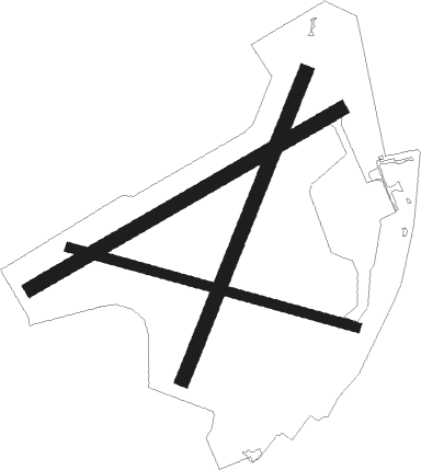
Runway info
Runway 07 / 25  | ||
| length | 1112m (3648ft) | |
| bearing | 73° / 253° | |
| width | 45m (148ft) | |
| surface | grass | |
| Runway 03 / 21 | ||
| length | 1029m (3376ft) | |
| bearing | 38° / 218° | |
| width | 45m (148ft) | |
| surface | grass | |
| Runway 11 / 29 | ||
| length | 925m (3035ft) | |
| bearing | 103° / 283° | |
| width | 30m (98ft) | |
| surface | grass | |
Nearby beacons
| code | identifier | dist | bearing | frequency |
|---|---|---|---|---|
| BUR | BURNHAM NDB | 3.8 | 79° | 421 |
| WOD | WOODLEY NDB | 4.8 | 245° | 352 |
| BLC | DME | 10.9 | 202° | 116.20 |
| BLK | BLACKBUSHE NDB | 10.9 | 202° | 328 |
| LON | LONDON VOR/DME | 11.5 | 92° | 113.60 |
| CHT | CHILTERN NDB | 12 | 64° | 277 |
| BSO | BENSON TACAN | 13.9 | 289° | 110 |
| HEN | HENTON NDB | 15.5 | 357° | 433 |
| BNN | BOVINGDON VOR/DME | 15.9 | 45° | 113.75 |
| CPT | COMPTON VOR/DME | 16.6 | 269° | 114.35 |
| OCK | OCKHAM VOR/DME | 16.9 | 121° | 115.30 |
| ODH | ODIHAM TACAN | 17.3 | 213° | 109.60 |
| EPM | EPSOM NDB | 18.6 | 114° | 316 |
| WCO | WESTCOTT NDB | 22.2 | 332° | 335 |
| MID | MIDHURST VOR/DME | 27.4 | 161° | 114 |
| OX | OXFORD NDB | 28.5 | 301° | 367 |
| BPK | BROOKMANS PARK VOR/DME | 29 | 70° | 117.50 |
| LUT | LUTON NDB | 30.6 | 53° | 345 |
| LCY | LONDON CITY NDB | 31.4 | 90° | 322 |
| BIG | BIGGIN VOR/DME | 31.9 | 102° | 115.10 |
| BZ | BRIZE NORTON NDB | 34.2 | 287° | 386 |
| BZN | BRIZE NORTON TACAN | 34.2 | 287° | 111.90 |
| LAM | LAMBOURNE VOR/DME | 35.6 | 81° | 115.60 |
| CIT | CRANFIELD NDB | 38.6 | 19° | 850 |
| GWC | GOODWOOD VOR/DME | 38.7 | 178° | 114.75 |
| SAM | SOUTHAMPTON VOR/DME | 39.1 | 226° | 113.35 |
| EAS | SOUTHAMPTON (EASTLEIGH) NDB | 39.3 | 227° | 391 |
| BDN | BOSCOMBE DOWN TACAN | 42.3 | 250° | 108.20 |
| BKY | BARKWAY VOR/DME | 42.7 | 60° | 116.25 |
| DTY | DAVENTRY VOR/DME | 42.7 | 333° | 116.40 |
| SHM | SHOREHAM NDB | 43.8 | 144° | 332 |
| SRH | DME-ILS | 43.8 | 144° | 109.95 |
| MAY | MAYFIELD VOR/DME | 44.3 | 118° | 117.90 |
| DET | DETLING VOR/DME | 52.7 | 98° | 117.30 |
| SND | SOUTHEND NDB | 55.2 | 87° | 362 |
| CAM | CAMBRIDGE NDB | 55.5 | 53° | 332 |
| SFD | SEAFORD VOR/DME | 55.8 | 130° | 117 |
| HLS | DME | 57.3 | 104° | 115.95 |
| LSH | HEADCORN (LASHENDEN) NDB | 57.3 | 104° | 340 |
| HON | HONILEY VOR/DME | 61 | 314° | 113.65 |
| BHX | BIRMINGHAM NDB | 67.7 | 314° | 406 |
| LYD | LYDD VOR/DME | 69 | 107° | 114.05 |
| MLD | MILDENHALL TACAN | 69.7 | 56° | 115.90 |
| LZD | LYDD NDB | 72.2 | 108° | 397 |
| LKH | LAKENHEATH TACAN | 73.1 | 56° | 110.20 |
| WTZ | WATTISHAM TACAN | 73.8 | 70° | 109.30 |
| CLN | CLACTON VOR/DME | 74.5 | 80° | 114.55 |
Disclaimer
The information on this website is not for real aviation. Use this data with the X-Plane flight simulator only! Data taken with kind consent from X-Plane 12 source code and data files. Content is subject to change without notice.