St. Neot's - Little Gransden
Airport details
| Country | United Kingdom |
| State | England |
| Region | EG |
| Airspace | London Ctr |
| Municipality | Cambridgeshire |
| Elevation | 250ft (76m) |
| Timezone | GMT +0 |
| Coordinates | 52.16667, -0.15383 |
| Magnetic var | |
| Type | land |
| Available since | X-Plane v10.40 |
| ICAO code | EGMJ |
| IATA code | n/a |
| FAA code | n/a |
Communication
Nearby Points of Interest:
Croxton Park
-Potton railway station
-Bourn Hall Clinic
-Sandy Warren
-Hardwick Wood
-Eaton Socon Castle
-Shortmead House
-Kneesworth House School
-St George's Church, Edworth
-Ashwell Bury
-Ashwell War Memorial
-Arbury Banks, Hertfordshire
-The Mansion House
-Royston Cave
-Farm Hall
-Southill Park
-Henlow Grange
-Old Vicarage, Grantchester
-The Manor
-Wardon Abbey
-Southill railway station
-Old Bridge, Huntingdon
-Hinchingbrooke House
-Town Hall
-Thriplow Meadows
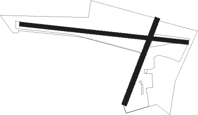
Runway info
Runway 10 / 28  | ||
| length | 763m (2503ft) | |
| bearing | 97° / 277° | |
| width | 18m (59ft) | |
| surface | grass | |
| displ threshold | 0m (0ft) / 192m (630ft) | |
| Runway 03 / 21 | ||
| length | 407m (1335ft) | |
| bearing | 38° / 218° | |
| width | 23m (75ft) | |
| surface | grass | |
Nearby beacons
| code | identifier | dist | bearing | frequency |
|---|---|---|---|---|
| CAM | CAMBRIDGE NDB | 12.6 | 83° | 332 |
| BKY | BARKWAY VOR/DME | 13.2 | 129° | 116.25 |
| CIT | CRANFIELD NDB | 15 | 265° | 850 |
| LUT | LUTON NDB | 16.7 | 200° | 345 |
| BPK | BROOKMANS PARK VOR/DME | 25.1 | 174° | 117.50 |
| MLD | MILDENHALL TACAN | 26.3 | 73° | 115.90 |
| WIT | WITTERING TACAN | 29.3 | 322° | 117.60 |
| LKH | LAKENHEATH TACAN | 29.5 | 71° | 110.20 |
| BNN | BOVINGDON VOR/DME | 30.2 | 222° | 113.75 |
| LAM | LAMBOURNE VOR/DME | 33.2 | 150° | 115.60 |
| HEN | HENTON NDB | 33.9 | 237° | 433 |
| CHT | CHILTERN NDB | 35.3 | 214° | 277 |
| DTY | DAVENTRY VOR/DME | 35.3 | 271° | 116.40 |
| WCO | WESTCOTT NDB | 35.3 | 249° | 335 |
| MAM | MARHAM TACAN | 38.9 | 56° | 108.70 |
| WTZ | WATTISHAM TACAN | 40.4 | 92° | 109.30 |
| LCY | LONDON CITY NDB | 40.6 | 162° | 322 |
| LE | LEICESTER NDB | 41.7 | 297° | 383 |
| LON | LONDON VOR/DME | 42.4 | 205° | 113.60 |
| BUR | BURNHAM NDB | 43.4 | 219° | 421 |
| SND | SOUTHEND NDB | 47.5 | 125° | 362 |
| BSO | BENSON TACAN | 48.2 | 240° | 110 |
| BIG | BIGGIN VOR/DME | 50.6 | 167° | 115.10 |
| WOD | WOODLEY NDB | 50.6 | 225° | 352 |
| EPM | EPSOM NDB | 51.5 | 194° | 316 |
| CLN | CLACTON VOR/DME | 51.7 | 104° | 114.55 |
| OCK | OCKHAM VOR/DME | 52.8 | 199° | 115.30 |
| CWL | CRANWELL NDB | 53 | 339° | 423 |
| CWZ | CRANWELL TACAN | 53.1 | 339° | 117.40 |
| CGY | CONINGSBY TACAN | 55.5 | 359° | 111.10 |
| BLC | DME | 56.7 | 219° | 116.20 |
| BLK | BLACKBUSHE NDB | 56.7 | 219° | 328 |
| DET | DETLING VOR/DME | 58.8 | 139° | 117.30 |
| WAD | WADDINGTON TACAN | 61.4 | 340° | 117.10 |
| ODH | ODIHAM TACAN | 63.4 | 220° | 109.60 |
Disclaimer
The information on this website is not for real aviation. Use this data with the X-Plane flight simulator only! Data taken with kind consent from X-Plane 12 source code and data files. Content is subject to change without notice.