Carlisle
Airport details
| Country | United Kingdom |
| State | England |
| Region | EG |
| Airspace | London Ctr |
| Municipality | Carlisle |
| Elevation | 187ft (57m) |
| Timezone | GMT +0 |
| Coordinates | 54.94084, -2.80836 |
| Magnetic var | |
| Type | land |
| Available since | X-Plane v10.40 |
| ICAO code | EGNC |
| IATA code | CAX |
| FAA code | n/a |
Communication
| Carlisle Carlisle Information | 118.430 |
| Carlisle Carlisle Tower | 123.605 |
| Carlisle Carlisle Approach | 123.605 |
Nearby Points of Interest:
Edmond Castle
-Scaleby Castle
-Holme Eden Abbey
-Our Lady and St. Wilfrid's Roman Catholic church, Warwick Bridge
-Warwick Hall
-Corby Castle
-Market Hall
-5 And 6, Greenmarket
-Crown Court, Adjoining Offices And Gate Arch
-Tithe Barn
-Tarn House
-Dalston Hall
-borders of the Roman Empire
-Battle of Solway Moss
-Cardew House
-Rose Castle
-Cardew Lodge
-Gilnockie Tower
-Calthwaite Hall
-Drumburgh Castle
-Coanwood Friends Meeting House
-Unthank Hall
-Skipper's Bridge
-St. John's Church
-Stapleton Tower
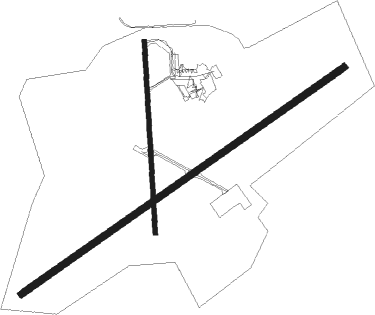
Runway info
Runway 06 / 24  | ||
| length | 1825m (5988ft) | |
| bearing | 71° / 251° | |
| width | 30m (98ft) | |
| surface | asphalt | |
| displ threshold | 200m (656ft) / 240m (787ft) | |
| Runway 01 / 19 | ||
| length | 886m (2907ft) | |
| bearing | 2° / 182° | |
| width | 22m (72ft) | |
| surface | asphalt | |
| displ threshold | 5m (16ft) / 120m (394ft) | |
Nearby beacons
| code | identifier | dist | bearing | frequency |
|---|---|---|---|---|
| DUF | DUN FELL DME | 19.7 | 126° | 115.25 |
| DCS | CROSS DME | 22.6 | 248° | 115.20 |
| TLA | TALLA VOR/DME | 38.3 | 316° | 113.80 |
| GLO | LOWTHER DME | 41.7 | 296° | 109.65 |
| WL | BARROW (WALNEY ISLAND) NDB | 51.3 | 209° | 385 |
| SAB | SAINT ABBS VOR/DME | 61.5 | 32° | 112.50 |
| UW | EDINBURGH NDB | 62.5 | 324° | 368 |
Disclaimer
The information on this website is not for real aviation. Use this data with the X-Plane flight simulator only! Data taken with kind consent from X-Plane 12 source code and data files. Content is subject to change without notice.