Kirmington - Humberside
Airport details
| Country | United Kingdom |
| State | England |
| Region | EG |
| Airspace | London Ctr |
| Municipality | Kirmington |
| Elevation | 121ft (37m) |
| Timezone | GMT +0 |
| Coordinates | 53.57444, -0.35083 |
| Magnetic var | |
| Type | land |
| Available since | X-Plane v10.30 |
| ICAO code | EGNJ |
| IATA code | HUY |
| FAA code | n/a |
Communication
| Humberside Humberside Information | 124.130 |
| Humberside Humberside Tower | 124.905 |
| Humberside Humberside Approach | 119.130 |
Approach frequencies
| ILS-cat-I | RW20 | 108.75 | 18.00mi |
| 3° GS | RW20 | 108.75 | 18.00mi |
Nearby Points of Interest:
St Mary's Church, Barnetby
-Brocklesby railway station
-Elsham Hall
-thornton hunt inn
-Killingholme High Lighthouse
-Killingholme South Low Lighthouse
-Killingholme North Low Lighthouse
-Bardney Hall
-The Bluebell Inn
-Tyrwhitt Hall
-Police Station
-Salvation Army Citadel (Former Primitive Methodist Chapel)
-United Reformed Church
-Assembly Rooms
-Odds Fellows Hall
-51 Fleetgate
-Horkstow Roman Villa
-St Andrew's Church, Redbourne
-Twigmore Hall
-Thorngumbald Clough High Lighthouse
-Thorngumbald Clough Low Lighthouse
-Kingerby Castle
-Town Hall
-Paull Lighthouse
-Cleatham Hall
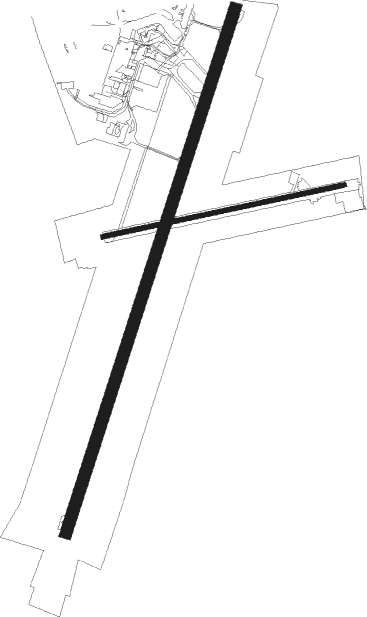
Runway info
Runway 02 / 20  | ||
| length | 2202m (7224ft) | |
| bearing | 35° / 215° | |
| width | 45m (148ft) | |
| surface | asphalt | |
| displ threshold | 0m (0ft) / 248m (814ft) | |
| Runway 08 / 26 | ||
| length | 988m (3241ft) | |
| bearing | 85° / 265° | |
| width | 18m (60ft) | |
| surface | asphalt | |
| displ threshold | 0m (0ft) / 290m (951ft) | |
Nearby beacons
| code | identifier | dist | bearing | frequency |
|---|---|---|---|---|
| KIM | HUMBERSIDE NDB | 0.1 | 262° | 365 |
| OTR | OTTRINGHAM VOR/DME | 11.5 | 63° | 113.90 |
| FNY | DONCASTER SHEFFIELD NDB | 23.9 | 261° | 338 |
| WAD | WADDINGTON TACAN | 25.3 | 203° | 117.10 |
| GAM | GAMSTON VOR/DME | 27.6 | 244° | 112.80 |
| CGY | CONINGSBY TACAN | 29.7 | 159° | 111.10 |
| CWZ | CRANWELL TACAN | 33.1 | 194° | 117.40 |
| SBL | SHERBURN-IN-ELMET NDB | 33.1 | 284° | 323 |
| CWL | CRANWELL NDB | 33.2 | 194° | 423 |
| EME | EAST MIDLANDS NDB | 53.9 | 229° | 353 |
| WIT | WITTERING TACAN | 58.2 | 189° | 117.60 |
| LE | LEICESTER NDB | 63.1 | 215° | 383 |
| MAM | MARHAM TACAN | 64.6 | 135° | 108.70 |
| TD | TEESSIDE INTL NDB | 68.6 | 315° | 347 |
Instrument approach procedures
| runway | airway (heading) | route (dist, bearing) |
|---|---|---|
| RW20 | OTR (243°) | OTR 2000ft LOUNA (5mi, 275°) 2000ft |
| RNAV | LOUNA 2000ft NJ20F (3mi, 215°) 2000ft EGNJ (6mi, 215°) 128ft NJM02 (5mi, 215°) 2000ft |
Disclaimer
The information on this website is not for real aviation. Use this data with the X-Plane flight simulator only! Data taken with kind consent from X-Plane 12 source code and data files. Content is subject to change without notice.