Angelsey - Raf Valley
Airport details
| Country | United Kingdom |
| State | Wales |
| Region | EG |
| Airspace | London Ctr |
| Municipality | Isle of Anglesey |
| Elevation | 37ft (11m) |
| Timezone | GMT +0 |
| Coordinates | 53.24306, -4.53586 |
| Magnetic var | |
| Type | land |
| Available since | X-Plane v10.40 |
| ICAO code | EGOV |
| IATA code | VYL |
| FAA code | n/a |
Communication
| RAF Valley ATIS | 120.725 |
| RAF Valley Tower | 122.100 |
| RAF Valley Approach | 125.225 |
Approach frequencies
| ILS-cat-I | RW13 | 108.55 | 18.00mi |
| 3° GS | RW13 | 108.55 | 18.00mi |
Nearby Points of Interest:
Llyn Maelog
-St Mihangel's Church
-St Mary's Church, Llanfair-yn-Neubwll
-Seilo Welsh Baptist Church
-St Gwenfaen's Church
-Valley Station Signal Box, Anglesey
-St Mary's Church, Tal-y-llyn
-St Peulan's Church
-St Cwyfan's Church
-Y Werthyr hillfort
-Melin Gwalchmai
-Llyn Llywenan
-Gwalchmai War Memorial
-Ebeneser Chapel
-St Trygarn's Church
-St Cynfarwy's Church
-Holyhead War Memorial
-Eglwys y Bedd
-Melin Hermon
-Holyhead Market Hall
-Cors Bodwrog
-Trefadog Castle
-St Ceinwen's Church
-Melin Frogwy
-Glannau Ynys Gybi
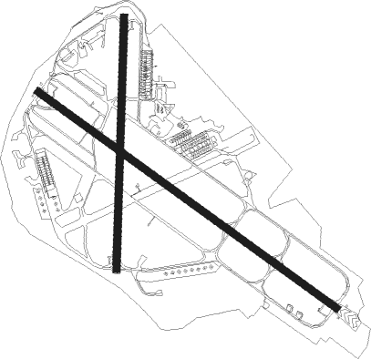
Runway info
Runway 13 / 31  | ||
| length | 2289m (7510ft) | |
| bearing | 117° / 297° | |
| width | 45m (148ft) | |
| surface | asphalt | |
| Runway 01 / 19 | ||
| length | 1565m (5135ft) | |
| bearing | 11° / 191° | |
| width | 45m (148ft) | |
| surface | asphalt | |
Nearby beacons
| code | identifier | dist | bearing | frequency |
|---|---|---|---|---|
| VYL | VALLEY TACAN | 0.4 | 305° | 108.40 |
| IOM | ISLE OF MAN VOR/DME | 50.1 | 345° | 112.20 |
| RWY | RONALDSWAY NDB | 50.4 | 354° | 359 |
Departure and arrival routes
| Transition altitude | 3000ft |
| SID end points | distance | outbound heading | |
|---|---|---|---|
| RW01 | |||
| MID01E | 20mi | 93° | |
| MID01S | 20mi | 175° | |
| RW13 | |||
| MID13E | 20mi | 93° | |
| MID13S | 20mi | 175° | |
| RW19 | |||
| MID19E | 20mi | 93° | |
| MID19S | 20mi | 175° | |
| RW31 | |||
| MID31E | 20mi | 93° | |
| MID31S | 20mi | 175° | |
Disclaimer
The information on this website is not for real aviation. Use this data with the X-Plane flight simulator only! Data taken with kind consent from X-Plane 12 source code and data files. Content is subject to change without notice.