Orkney Islands - Kirkwall
Airport details
| Country | United Kingdom |
| State | Scotland |
| Region | EG |
| Airspace | Scottish Ctr |
| Municipality | Orkney Islands |
| Elevation | 47ft (14m) |
| Timezone | GMT +0 |
| Coordinates | 58.95806, -2.90056 |
| Magnetic var | |
| Type | land |
| Available since | X-Plane v10.40 |
| ICAO code | EGPA |
| IATA code | KOI |
| FAA code | n/a |
Communication
| Kirkwall Kirkwall Information | 108.600 |
| Kirkwall Kirkwall Tower | 118.305 |
| Kirkwall Kirkwall Approach | 118.305 |
Approach frequencies
| ILS-cat-I | RW27 | 110.1 | 18.00mi |
| ILS-cat-I | RW09 | 110.1 | 18.00mi |
| 3.5° GS | RW27 | 110.1 | 18.00mi |
| 3.5° GS | RW09 | 110.1 | 18.00mi |
Nearby Points of Interest:
Wideford Hill Chambered Cairn
-East Broch of Burray
-Mor Stein
-Waulkmill Bay
-Heart of Neolithic Orkney
-Hall of Clestrain
-Loch of Harray
-Rousay, Trumland House
-Loch of Stenness
-Hackness Martello Tower and Battery
-Eynhallow Church
-Bay of Skaill
-Broch of Borwick
-Sandwick, St Peter's Kirk
-Stanerandy,mound and two standing stones 100m SSE of Little Favel
-chambered cairn on Vinquoy Hill
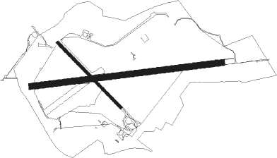
Runway info
Runway 09 / 27  | ||
| length | 1436m (4711ft) | |
| bearing | 89° / 269° | |
| width | 46m (151ft) | |
| surface | asphalt | |
| displ threshold | 167m (548ft) / 40m (131ft) | |
| Runway 14 / 32 | ||
| length | 675m (2215ft) | |
| bearing | 122° / 302° | |
| width | 18m (59ft) | |
| surface | asphalt | |
| displ threshold | 0m (0ft) / 119m (390ft) | |
Nearby beacons
| code | identifier | dist | bearing | frequency |
|---|---|---|---|---|
| KW | KIRKWALL NDB | 0 | 46° | 395 |
| KWL | KIRKWALL VOR/DME | 0.2 | 76° | 108.60 |
| WIK | WICK VOR/DME | 30.6 | 202° | 113.60 |
| WCK | WICK NDB | 31.1 | 198° | 344 |
Instrument approach procedures
| runway | airway (heading) | route (dist, bearing) |
|---|---|---|
| RW09 | ATMEX (89°) | ATMEX 2600ft PA09I (4mi, 89°) 2100ft |
| RW09 | TUVIV (99°) | TUVIV 2100ft PA09I (4mi, 141°) 2100ft |
| RW09 | UPLAB (78°) | UPLAB 2600ft PA09I (4mi, 31°) 2100ft |
| RNAV | PA09I 2100ft PA09F (4mi, 89°) 2000ft EGPA (5mi, 89°) 89ft PAM01 (5mi, 89°) PAM02 (5mi, 355°) PAM03 (5mi, 269°) KW (5mi, 176°) 2600ft KW (turn) 2600ft | |
| RW27 | ABTOR (282°) | ABTOR 2600ft RUDKU (4mi, 355°) 1600ft |
| RW27 | IVDIS (255°) | IVDIS 2600ft RUDKU (4mi, 175°) 1600ft |
| RNAV | RUDKU 1600ft PA27F (4mi, 269°) 1600ft MA27 (4mi, 269°) 275ft PAM04 (6mi, 269°) PAM05 (5mi, 175°) PAM06 (5mi, 89°) KW (5mi, 355°) 2600ft KW (turn) 2600ft |
Disclaimer
The information on this website is not for real aviation. Use this data with the X-Plane flight simulator only! Data taken with kind consent from X-Plane 12 source code and data files. Content is subject to change without notice.