Old Buckenham
Airport details
| Country | United Kingdom |
| State | England |
| Region | EG |
| Airspace | London Ctr |
| Municipality | Breckland District |
| Elevation | 191ft (58m) |
| Timezone | GMT +0 |
| Coordinates | 52.49750, 1.05194 |
| Magnetic var | |
| Type | land |
| Available since | X-Plane v10.40 |
| ICAO code | EGSV |
| IATA code | n/a |
| FAA code | n/a |
Communication
| Old Buckenham Buckenham Radio | 124.400 |
Nearby Points of Interest:
Great Ellingham Windmill
-Tacolneston Hall
-Aslacton Windmill
-Kenninghall Road Mill
-Rainthorpe Hall
-Manor Farm
-Hopton Fen
-Letton Hall
-Merton Hall
-East Wretham Heath
-Market Weston Fen
-St Botolph's Chapel
-Starston Windpump
-Earlham Hall
-Kilverstone Hall
-East Dereham Windmill
-the assembly house
-42-48 Bethel Street
-Surrey House
-City Hall, Norwich
-Norwich Guildhall
-St Gregory's Church
-The Ferry Boat Inn
-Bixley medieval settlement
-Shire House
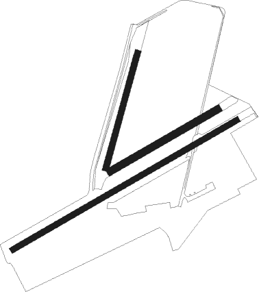
Runway info
Runway 02 / 20  | ||
| length | 368m (1207ft) | |
| bearing | 31° / 211° | |
| width | 18m (59ft) | |
| surface | grass | |
| Runway 07L / 25R | ||
| length | 381m (1250ft) | |
| bearing | 74° / 254° | |
| width | 23m (75ft) | |
| surface | grass | |
| Runway 07 / 25 | ||
| length | 796m (2612ft) | |
| bearing | 74° / 254° | |
| width | 18m (59ft) | |
| surface | asphalt | |
| displ threshold | 0m (0ft) / 157m (515ft) | |
Nearby beacons
| code | identifier | dist | bearing | frequency |
|---|---|---|---|---|
| NWI | NORWICH NDB | 13.9 | 53° | 342 |
| LKH | LAKENHEATH TACAN | 19.2 | 260° | 110.20 |
| MAM | MARHAM TACAN | 20 | 287° | 108.70 |
| MLD | MILDENHALL TACAN | 22.1 | 257° | 115.90 |
| WTZ | WATTISHAM TACAN | 22.9 | 197° | 109.30 |
| CAM | CAMBRIDGE NDB | 36.2 | 252° | 332 |
| CLN | CLACTON VOR/DME | 39.1 | 172° | 114.55 |
| BKY | BARKWAY VOR/DME | 47.4 | 243° | 116.25 |
| CGY | CONINGSBY TACAN | 56.8 | 296° | 111.10 |
| SND | SOUTHEND NDB | 56.8 | 201° | 362 |
| WIT | WITTERING TACAN | 57 | 274° | 117.60 |
| LUT | LUTON NDB | 60.1 | 245° | 345 |
| LAM | LAMBOURNE VOR/DME | 60.9 | 227° | 115.60 |
| BPK | BROOKMANS PARK VOR/DME | 61.9 | 237° | 117.50 |
| CIT | CRANFIELD NDB | 63 | 257° | 850 |
| CWL | CRANWELL NDB | 64.3 | 289° | 423 |
| CWZ | CRANWELL TACAN | 64.3 | 289° | 117.40 |
| LCY | LONDON CITY NDB | 69.8 | 225° | 322 |
| WAD | WADDINGTON TACAN | 69.9 | 293° | 117.10 |
Disclaimer
The information on this website is not for real aviation. Use this data with the X-Plane flight simulator only! Data taken with kind consent from X-Plane 12 source code and data files. Content is subject to change without notice.