Mildenhall - Raf Mildenhall
Airport details
| Country | United Kingdom |
| State | England |
| Region | EG |
| Airspace | London Ctr |
| Municipality | West Suffolk |
| Elevation | 33ft (10m) |
| Timezone | GMT +0 |
| Coordinates | 52.36195, 0.48639 |
| Magnetic var | |
| Type | land |
| Available since | X-Plane v10.40 |
| ICAO code | EGUN |
| IATA code | MHZ |
| FAA code | n/a |
Communication
| RAF Mildenhall Mildenhall Ground | 121.675 |
| RAF Mildenhall Mildenhall Tower | 122.550 |
| RAF Mildenhall Lakenheath Approach | 136.500 |
Approach frequencies
| ILS-cat-I | RW10 | 110.15 | 18.00mi |
| ILS-cat-I | RW28 | 110.15 | 18.00mi |
| 2.9° GS | RW10 | 110.15 | 18.00mi |
| 2.9° GS | RW28 | 110.15 | 18.00mi |
Nearby Points of Interest:
Foxhole Heath
-Berner's Heath
-Black Ditches, Cavenham
-Elveden Hall
-West Stow Hall
-Dalham Hall
-Spinney Abbey
-Lower Mill, Dalham
-Culford Park
-Bishop's Palace Bishop's Palace (the Palace School)
-Ampton Hall
-Guildhall
-Thetford Castle
-Kirtling Tower
-Market Cross
-Northgate House
-Bury St Edmunds Guildhall
-Pillar of Salt
-Euston Hall
-Kilverstone Hall
-Quy Hall
-East Wretham Heath
-Tutelina Mill
-Nether Hall
-Ryston Hall
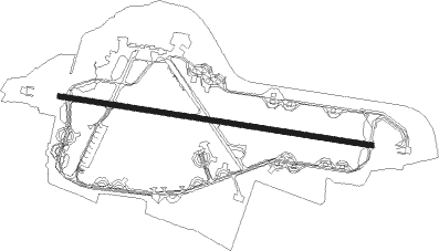
Runway info
| Runway 11 / 29 | ||
| length | 2799m (9183ft) | |
| bearing | 98° / 278° | |
| width | 42m (138ft) | |
| surface | asphalt | |
| blast zone | 255m (837ft) / 255m (837ft) | |
Nearby beacons
| code | identifier | dist | bearing | frequency |
|---|---|---|---|---|
| MLD | MILDENHALL TACAN | 0.1 | 54° | 115.90 |
| LKH | LAKENHEATH TACAN | 3.4 | 54° | 110.20 |
| CAM | CAMBRIDGE NDB | 14.3 | 244° | 332 |
| MAM | MARHAM TACAN | 17.3 | 15° | 108.70 |
| WTZ | WATTISHAM TACAN | 22 | 118° | 109.30 |
| BKY | BARKWAY VOR/DME | 27.2 | 229° | 116.25 |
| NWI | NORWICH NDB | 34.9 | 69° | 342 |
| WIT | WITTERING TACAN | 38.9 | 284° | 117.60 |
| LUT | LUTON NDB | 39.1 | 238° | 345 |
| CLN | CLACTON VOR/DME | 39.3 | 128° | 114.55 |
| CIT | CRANFIELD NDB | 40.8 | 257° | 850 |
| BPK | BROOKMANS PARK VOR/DME | 42.7 | 224° | 117.50 |
| LAM | LAMBOURNE VOR/DME | 44.7 | 205° | 115.60 |
| SND | SOUTHEND NDB | 47.8 | 165° | 362 |
| CGY | CONINGSBY TACAN | 49.8 | 318° | 111.10 |
| CWL | CRANWELL NDB | 53.4 | 304° | 423 |
| CWZ | CRANWELL TACAN | 53.4 | 304° | 117.40 |
| LCY | LONDON CITY NDB | 53.7 | 206° | 322 |
| BNN | BOVINGDON VOR/DME | 54 | 238° | 113.75 |
| LE | LEICESTER NDB | 57.5 | 279° | 383 |
| CHT | CHILTERN NDB | 57.8 | 234° | 277 |
| HEN | HENTON NDB | 59.4 | 245° | 433 |
| DTY | DAVENTRY VOR/DME | 59.8 | 264° | 116.40 |
| WAD | WADDINGTON TACAN | 60.6 | 308° | 117.10 |
| WCO | WESTCOTT NDB | 61.5 | 251° | 335 |
| LON | LONDON VOR/DME | 63.2 | 227° | 113.60 |
| BUR | BURNHAM NDB | 66.4 | 234° | 421 |
| EME | EAST MIDLANDS NDB | 67.5 | 286° | 353 |
| BSO | BENSON TACAN | 73.8 | 245° | 110 |
| OX | OXFORD NDB | 73.9 | 254° | 367 |
| WOD | WOODLEY NDB | 74.4 | 236° | 352 |
Departure and arrival routes
| Transition altitude | 3000ft |
| SID end points | distance | outbound heading | |
|---|---|---|---|
| RW10 | |||
| NUGTU2 | 23mi | 311° | |
| RW28 | |||
| NUGTU2 | 23mi | 311° | |
Instrument approach procedures
| runway | airway (heading) | route (dist, bearing) |
|---|---|---|
| RW10 | IRDAB (98°) | IRDAB 2600ft |
| RNAV | IRDAB 2600ft UGDAB (6mi, 98°) 1600ft EGUN (6mi, 98°) 89ft (3145mi, 181°) 432ft IBUTU (3143mi, 1°) EKVOB (5mi, 119°) 2600ft EKVOB (turn) 7000ft | |
| RW28 | TUSMU (278°) | TUSMU 2600ft |
| RNAV | TUSMU 2600ft XOTKU (6mi, 278°) 1600ft TUXUT (3mi, 278°) 800ft EGUN (3mi, 278°) 96ft (3145mi, 181°) 432ft OKNEN (3146mi, 0°) BAXED (10mi, 279°) 2600ft BAXED (turn) 10000ft |
Disclaimer
The information on this website is not for real aviation. Use this data with the X-Plane flight simulator only! Data taken with kind consent from X-Plane 12 source code and data files. Content is subject to change without notice.