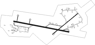
Mount Pleasant
Airport details
| Country | Falkland Islands |
| State | Falkland Islands |
| Region | SF |
| Airspace | Comodoro Rivadavia Ctr |
| Municipality | Forge Island |
| Elevation | 244ft (74m) |
| Timezone | GMT -3 |
| Coordinates | -51.82164, -58.47617 |
| Magnetic var | |
| Type | land |
| Available since | X-Plane v10.40 |
| ICAO code | EGYP |
| IATA code | MPN |
| FAA code | n/a |
Communication
| Mount Pleasant Ground Control | 130.300 |
| Mount Pleasant Tower | 133.350 |
| Mount Pleasant ISLAND Radar | 132.500 |
Approach frequencies
| ILS-cat-I | RW28 | 111.9 | 18.00mi |
| 3° GS | RW28 | 111.9 | 18.00mi |
Nearby Points of Interest:
Puerto Soledad
-Stanley
Nearby beacons
| code | identifier | dist | bearing | frequency |
|---|---|---|---|---|
| MP | MOUNT PLEASANT NDB | 0.4 | 198° | 380 |
| MPA | MOUNT PLEASANT TACAN | 0.7 | 97° | 112.20 |
| MTP | MOUNT PLEASANT VOR | 1.9 | 95° | 114.70 |
| DFO | DME | 27.2 | 79° | 113.30 |
| SA | STANLEY NDB | 27.2 | 79° | 305 |
Instrument approach procedures
| runway | airway (heading) | route (dist, bearing) |
|---|---|---|
| RW10 | YP421 (100°) | YP421 3610ft YP420 (5mi, 100°) 3210ft |
| RW10 | YP422 (116°) | YP422 3610ft YP420 (5mi, 204°) 3210ft |
| RW10 | YP423 (87°) | YP423 3610ft YP420 (5mi, 24°) 3210ft |
| RNAV | YP420 3200ft YP419 (6mi, 100°) 2600ft YP418 (3mi, 100°) 1720ft EGYP (4mi, 102°) 283ft (4273mi, 48°) 2010ft YP423 (4285mi, 229°) 3610ft YP423 (turn) 3610ft | |
| RW28 | YP431 (279°) | YP431 3600ft YP430 (5mi, 279°) 3200ft |
| RW28 | YP432 (292°) | YP432 3600ft YP430 (5mi, 23°) 3200ft |
| RW28 | YP433 (267°) | YP433 3600ft YP430 (5mi, 203°) 3200ft |
| RNAV | YP430 3200ft YP428 (6mi, 279°) 2600ft MA28 (7mi, 280°) 470ft (4271mi, 48°) 700ft YP432 (4265mi, 228°) 3600ft YP432 (turn) 3600ft |
Disclaimer
The information on this website is not for real aviation. Use this data with the X-Plane flight simulator only! Data taken with kind consent from X-Plane 12 source code and data files. Content is subject to change without notice.

