Airports for X-Plane offers a convenient way to explore airports and their related communication information for the X-Plane flight simulator. It only uses data from the X-Plane flight simulator itself, and is therefore more reliable than the data that comes from real aviation websites. You can search for airports by using the ICAO code, or browse for airports per country and state. The information displayed is categorized by airport details, runway information, airport communication, approach frequencies (ILS and Glidepath details), details of nearby beacons, SIDs, STARs and approach procedures.

automated airport weather station consulate ferry passenger tarmac faa airspeed field government terminal concrete aircraft carrier jet embassy takeoff city runway aircraft warfare arriving

Leiden - Valkenburg

Airport details

CountryNetherlands
StateSouth Holland
RegionEH
AirspaceAmsterdam Ctr
MunicipalityValkenburg
Elevation0ft (0m)
TimezoneGMT +1
Coordinates52.17152, 4.42051
Magnetic var
Typeland
Available sinceX-Plane v10.40
ICAO codeEHVB
IATA codeLID
FAA coden/a

Communication

VALKENBURG EHVB-Tower134.150
Nearby Points of Interest:
Valkenburg Naval Air Base
-
Water tower in Katwijk
-
Observatiepost
-
De Witte Hoogt
-
Obelisk Kasteel Endegeest
-
Zeeweg 144, Katwijk
-
Gemeenteschool Hoge Morsweg
-
Gemeentehuis (Katwijk)
-
Oude Raadhuis, Wassenaar
-
Baljuwhuis
-
Den Hoogenboom
-
Pesthuis, Leiden
-
Haagweg 13, Leiden
-
Koning Willem-Alexander gemaal
-
Rijnzichtbrug
-
Ambachtsschool
-
Huize De Paauw
-
Gebouw Leisch Dagblad
-
Kweekschool voor Zeevaart
-
Stadstimmerwerf
-
landgoed kasteel oud-poelgeest
-
De Pauwhof
-
Pieter Loridans Hofje
-
Doelenkazerne, Leiden
-
Gijselaarsbank

Runway info

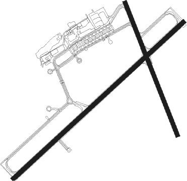
Runway 05 / 23  
 length2434m (7986ft)
 bearing64° / 244°
 width45m (148ft)
 surfaceasphalt
Runway 16 / 34  
 length1498m (4915ft)
 bearing153° / 333°
 width45m (148ft)
 surfaceasphalt
 displ threshold0m (0ft) / 100m (328ft)

Airport layout


Nearby beacons

codeidentifierdistbearingfrequency
RTMROTTERDAM VOR/DME12163°110.40
AMSDME14.261°113.95
SPLSCHIPHOL (AMSTERDAM) VOR/DME15.464°108.40
FRTDME16.3116°117.15
PAMPAMPUS VOR/DME26.576°117.80
SPYDME27.250°113.30
GZRGILZE-RIJEN TACAN41140°116.40
WDTWOENSDRECHT TACAN43.5186°115
HDRHELDER DME45.925°115.55
EHVEINDHOVEN TACAN56127°117.20
ANTANTWERP (DEURNE) VOR/DME58.9177°113.50

Disclaimer

The information on this website is not for real aviation. Use this data with the X-Plane flight simulator only! Data taken with kind consent from X-Plane 12 source code and data files. Content is subject to change without notice.