Nenagh - Erinagh
Airport details
| Country | Ireland |
| State | County Tipperary |
| Region | |
| Airspace | Shannon Ctr |
| Municipality | The Municipal District of Nenagh |
| Elevation | 153ft (47m) |
| Timezone | GMT +0 |
| Coordinates | 52.81250, -8.28222 |
| Magnetic var | |
| Type | land |
| Available since | X-Plane v10.40 |
| ICAO code | EIER |
| IATA code | n/a |
| FAA code | n/a |
Communication
Nearby Points of Interest:
Shantraud Ogham-Runic Stone
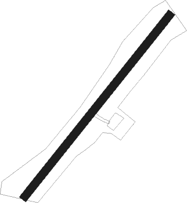
Runway info
| Runway 04 / 22 | ||
| length | 653m (2142ft) | |
| bearing | 57° / 237° | |
| width | 22m (72ft) | |
| surface | grass | |
Nearby beacons
| code | identifier | dist | bearing | frequency |
|---|---|---|---|---|
| OL | SHANNON NDB | 20 | 263° | 339 |
| SHA | SHANNON VOR/DME | 22.5 | 261° | 113.30 |
| WTP | DME | 30.2 | 68° | 116.30 |
| CML | CLONMEL NDB | 36.3 | 114° | 387 |
| FOY | FOYNES NDB | 36.3 | 255° | 395 |
| CRK | CORK VOR/DME | 58.8 | 192° | 114.60 |
Disclaimer
The information on this website is not for real aviation. Use this data with the X-Plane flight simulator only! Data taken with kind consent from X-Plane 12 source code and data files. Content is subject to change without notice.