Aarhus
Airport details
| Country | Denmark |
| State | Central Denmark Region |
| Region | EK |
| Airspace | Copenhagen Ctr |
| Municipality | Syddjurs Municipality |
| Elevation | 82ft (25m) |
| Timezone | GMT +1 |
| Coordinates | 56.30002, 10.61901 |
| Magnetic var | |
| Type | land |
| Available since | X-Plane v10.30 |
| ICAO code | EKAH |
| IATA code | AAR |
| FAA code | n/a |
Communication
| Aarhus Tower | 118.525 |
| Aarhus Approach | 119.275 |
Approach frequencies
| ILS-cat-II | RW28L | 111.1 | 18.00mi |
| ILS-cat-I | RW10R | 111.9 | 18.00mi |
| 2.7° GS | RW10R | 111.9 | 18.00mi |
| 2.7° GS | RW28L | 111.1 | 18.00mi |
Nearby Points of Interest:
Kolind runestone
-Øster Alling stone
-Krogsbæk Ødekirkegård
-Virring runestone
-Det norske hus
-Clausholm Castle
-Aarhus Custom House
-Business- and Agricultural Bank of Jutland
-Trods Katholm
-Mønsted's House
-Aarhus City Hall
-Aarhus Courthouse
-Smykkeskrinet
-Ridehuset
-Ole Rømer Observatory
-Thorald's House
-Bådstedgård
-Kysing Kirkeruin
-Favrskov
-Mejlbystenen
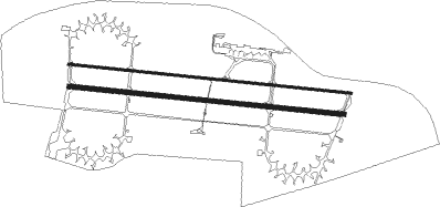
Runway info
Runway 10L / 28R  | ||
| length | 2768m (9081ft) | |
| bearing | 96° / 276° | |
| width | 23m (75ft) | |
| surface | asphalt | |
| Runway 10R / 28L | ||
| length | 2693m (8835ft) | |
| bearing | 96° / 276° | |
| width | 45m (148ft) | |
| surface | asphalt | |
| blast zone | 255m (837ft) / 225m (738ft) | |
Nearby beacons
| code | identifier | dist | bearing | frequency |
|---|---|---|---|---|
| TL | AARHUS NDB | 0 | 319° | 384 |
| TNO | TRANO VOR/DME | 41.8 | 123° | 117.40 |
| ODN | ODIN VOR/DME | 43.1 | 177° | 115.50 |
| FE | ODENSE NDB | 47.1 | 191° | 423 |
| AAL | AALBORG VORTAC | 52.4 | 322° | 116.70 |
Instrument approach procedures
| runway | airway (heading) | route (dist, bearing) |
|---|---|---|
| RW10R | ALINI (109°) | ALINI AH102 (5mi, 162°) 2000ft |
| RW10R | GINUB (84°) | GINUB AH102 (5mi, 46°) 2000ft |
| RW10R | RUDOV (96°) | RUDOV AH102 (5mi, 96°) 2000ft |
| RNAV | AH102 2000ft AH101 (4mi, 96°) 2000ft EKAH (7mi, 97°) 131ft AH104 (4mi, 94°) GINUB (17mi, 267°) GINUB (turn) 4000ft | |
| RW28L | BADUT (264°) | BADUT AH282 (5mi, 227°) 2000ft |
| RW28L | DESOM (288°) | DESOM AH282 (5mi, 343°) 2000ft |
| RW28L | IBEKO (275°) | IBEKO AH282 (5mi, 276°) 2000ft |
| RNAV | AH282 2000ft AH281 (4mi, 276°) 2000ft EKAH (7mi, 275°) 125ft AH284 (4mi, 277°) BADUT (17mi, 87°) 4000ft BADUT (turn) 4000ft |
Disclaimer
The information on this website is not for real aviation. Use this data with the X-Plane flight simulator only! Data taken with kind consent from X-Plane 12 source code and data files. Content is subject to change without notice.