Groenholt
Airport details
| Country | Denmark |
| State | Capital Region of Denmark |
| Region | EK |
| Airspace | Copenhagen Ctr |
| Municipality | Fredensborg Municipality |
| Elevation | 98ft (30m) |
| Timezone | GMT +1 |
| Coordinates | 55.93972, 12.38194 |
| Magnetic var | |
| Type | land |
| Available since | X-Plane v10.40 |
| ICAO code | EKGH |
| IATA code | n/a |
| FAA code | n/a |
Communication
| Groenholt Groenholt Radio | 122.500 |
| Groenholt Copenhagen Information | 127.075 |
Nearby Points of Interest:
Store Dyrehave
-Par force hunting landscape in North Zealand
-Chaluphuset
-Frederiksborg Latin School
-Favrholm
-Gribskov
-Krogerup
-Sophienberg
-Rudersdal Town Hall
-Frydenlund
-Enrum
-Carlsminde
-Kingo Houses
-Ørholm
-De Ovale Haver
-Carmelite Priory, Helsingør
-Stephen Hansen Mansion
-Hellebækgård
-Grevinde Danners Palæ
-Rytterhuset
-Fæstningskanalen
-Raadvad Mølle
-Sankt Ibbs socken
-Christianelyst
-Marienborg
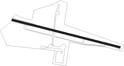
Runway info
| Runway 11 / 29 | ||
| length | 1005m (3297ft) | |
| bearing | 101° / 281° | |
| width | 18m (59ft) | |
| surface | asphalt | |
| displ threshold | 140m (459ft) / 300m (984ft) | |
Nearby beacons
| code | identifier | dist | bearing | frequency |
|---|---|---|---|---|
| BEL | DME | 13.1 | 243° | 114.65 |
| SVD | DME | 15.1 | 40° | 116.20 |
| KAS | KASTRUP (COPENHAGEN) VOR/DME | 22.3 | 146° | 112.50 |
| RK | ROSKILDE (COPENHAGEN) NDB | 23 | 231° | 368 |
| AH | ANGELHOLM NDB | 26.1 | 58° | 417 |
| LB | ANGELHOLM NDB | 27.6 | 43° | 370 |
| LJU | LJUNGBYHED VOR/DME | 28.8 | 80° | 113.40 |
| TNO | TRANO VOR/DME | 33.2 | 260° | 117.40 |
| KOR | KORSA VOR/DME | 39.3 | 236° | 112.80 |
| SUP | STURUP (MALMO) VOR/DME | 41.5 | 112° | 113 |
| MF | HALMSTAD NDB | 45.1 | 31° | 421 |
| LT | HALMSTAD NDB | 53.7 | 28° | 336 |
| CDA | CODAN VOR/DME | 56.3 | 180° | 114.90 |
Disclaimer
The information on this website is not for real aviation. Use this data with the X-Plane flight simulator only! Data taken with kind consent from X-Plane 12 source code and data files. Content is subject to change without notice.