Karup - Karup / Midtjyllands Lufthavn
Airport details
| Country | Denmark |
| State | Central Denmark Region |
| Region | EK |
| Airspace | Copenhagen Ctr |
| Municipality | Viborg Municipality |
| Elevation | 167ft (51m) |
| Timezone | GMT +1 |
| Coordinates | 56.30120, 9.08957 |
| Magnetic var | |
| Type | land |
| Available since | X-Plane v10.40 |
| ICAO code | EKKA |
| IATA code | KRP |
| FAA code | n/a |
Communication
| Karup / Midtjyllands Lufthavn Tower | 119.575 |
| Karup / Midtjyllands Lufthavn Approach | 120.425 |
| Karup / Midtjyllands Lufthavn Departure | 119.575 |
Approach frequencies
| ILS-cat-II | RW27L | 108.15 | 18.00mi |
| ILS-cat-I | RW09R | 108.3 | 18.00mi |
| 3° GS | RW09R | 108.3 | 18.00mi |
| 3° GS | RW27L | 108.15 | 18.00mi |
Nearby Points of Interest:
Hald Manor
-Højris
-Remisen
-Tvis Abbey
-Svaneapoteket
-Domprovstegården
-Friedenreichs Gård
-Den lille gård på Torvet
-Stillings Gård
-Gamle Vagt
-Latinskolen
-Generalkommandoen
-Salomon Gerbers Gård
-Skolestræde 1
-Skolestræde 2
-Exercerhuset
-Sankt Mogensgade 7
-Morvilles Gård
-Villadsens Gård
-Bispegården
-Sankt Mogensgade 11
-Det Zahrtmannske Hus
-Hans Werrings Gård
-Konrektors Gård
-Karnapgården
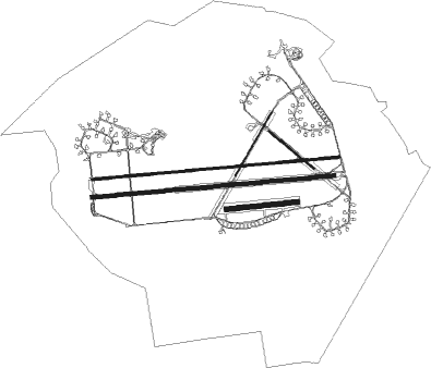
Runway info
Runway 09L / 27R  | ||
| length | 2986m (9797ft) | |
| bearing | 90° / 270° | |
| width | 23m (75ft) | |
| surface | asphalt | |
| blast zone | 175m (574ft) / 139m (456ft) | |
| Runway 09R / 27L | ||
| length | 2925m (9596ft) | |
| bearing | 90° / 270° | |
| width | 45m (148ft) | |
| surface | asphalt | |
| blast zone | 224m (735ft) / 226m (741ft) | |
| Runway 03 / 21 | ||
| length | 881m (2890ft) | |
| bearing | 51° / 231° | |
| width | 15m (49ft) | |
| surface | asphalt | |
| Runway 09 / 27 | ||
| length | 851m (2792ft) | |
| bearing | 89° / 269° | |
| width | 60m (197ft) | |
| surface | grass | |
| Runway 14 / 32 | ||
| length | 694m (2277ft) | |
| bearing | 119° / 299° | |
| width | 23m (75ft) | |
| surface | asphalt | |
Nearby beacons
| code | identifier | dist | bearing | frequency |
|---|---|---|---|---|
| KAR | KARUP TACAN | 2.7 | 267° | 110 |
| VJ | STAUNING NDB | 29.1 | 245° | 328 |
| LME | DME | 30.7 | 247° | 115.35 |
| AU | STAUNING NDB | 31.8 | 248° | 346 |
| RAM | DME | 31.8 | 281° | 111.85 |
| EJ | ESBJERG NDB | 47.4 | 207° | 400 |
| ESE | DME | 50 | 214° | 116.60 |
| KD | KOLDING NDB | 52.1 | 164° | 357 |
| VAM | DME | 52.4 | 164° | 110.05 |
| HP | ESBJERG NDB | 52.6 | 221° | 376 |
| AAL | AALBORG VORTAC | 56.7 | 48° | 116.70 |
Instrument approach procedures
| runway | airway (heading) | route (dist, bearing) |
|---|---|---|
| RW09R | BAMRU (100°) | BAMRU REVBO (5mi, 145°) 2000ft |
| RW09R | EBISO (77°) | EBISO REVBO (5mi, 32°) 2000ft |
| RNAV | REVBO 2000ft KA099 (5mi, 90°) 2000ft EKKA (6mi, 88°) 196ft KA09E (5mi, 91°) 1000ft KA09E (turn) 2000ft | |
| RW27L | GIROG (260°) | GIROG RIKSU (5mi, 213°) 2000ft |
| RW27L | LIRGO (281°) | LIRGO RIKSU (5mi, 326°) 2000ft |
| RNAV | RIKSU 2000ft KA279 (5mi, 270°) 2000ft EKKA (7mi, 271°) 209ft KA27W (4mi, 268°) 1000ft KA27W (turn) 2000ft |
Disclaimer
The information on this website is not for real aviation. Use this data with the X-Plane flight simulator only! Data taken with kind consent from X-Plane 12 source code and data files. Content is subject to change without notice.